Premium Framed Print > Arts > Realistic drawings > Still life artwork > Fine art
Premium Framed Print : Wreck Chart of the British Isles For 1868


![]()
Framed Photos from Mary Evans Picture Library
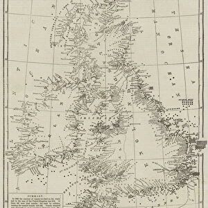
Wreck Chart of the British Isles For 1868
Chart showing the positions of all 2131 vessels wrecked around the British Isles during 1868, compiled from the Board of Trade records. The positions of lifeboat stations are also marked on this chart, with small banana shapes
Mary Evans Picture Library makes available wonderful images created for people to enjoy over the centuries
Media ID 4386259
© Mary Evans Picture Library 2015 - https://copyrighthub.org/s0/hub1/creation/maryevans/MaryEvansPictureID/10216983
1868 1869 Banana Chart Compiled Isles Life Boat Marked Positions Records Shapes Stations Vessels Wreck Wrecked
14"x16" Premium Frame
Contemporary style Premium Wooden Frame with 8"x10" Print. Complete with 2" White Mat and 1.25" thick MDF frame. Printed on 260 gsm premium paper. Glazed with shatter proof UV coated acrylic glass. Backing is paper covered backing with rubber bumpers. Supplied ready to hang with a pre-installed sawtooth/wire hanger. Care Instructions: Spot clean with a damp cloth. Securely packaged in a clear plastic bag and envelope in a reinforced cardboard shipper
FSC Real Wood Frame and Double Mounted with White Conservation Mountboard - Professionally Made and Ready to Hang
Estimated Image Size (if not cropped) is 20.3cm x 25.4cm (8" x 10")
Estimated Product Size is 35.6cm x 40.6cm (14" x 16")
These are individually made so all sizes are approximate
Artwork printed orientated as per the preview above, with portrait (vertical) orientation to match the source image.
FEATURES IN THESE COLLECTIONS
> Arts
> Realistic drawings
> Still life artwork
> Fine art
> Maps and Charts
> Related Images
EDITORS COMMENTS
This fascinating historical print from Mary Evans Prints Online showcases a Wreck Chart of the British Isles for 1868, detailing the positions of all 2131 vessels that were wrecked around the British Isles during that year. Compiled from Board of Trade records, this chart provides a unique insight into the maritime history of the region.
The positions of lifeboat stations are also marked on this chart, represented by small banana shapes. These stations played a crucial role in rescuing sailors and passengers from shipwrecks, highlighting the importance of lifesaving efforts along the treacherous coasts of the British Isles.
This intricate chart is not just a document of past tragedies but also serves as a reminder of the dangers faced by seafarers in years gone by. It offers a glimpse into a time when navigation was fraught with peril and shipwrecks were an all too common occurrence.
Whether you're interested in maritime history or simply appreciate unique historical artifacts, this Wreck Chart is sure to captivate your imagination. Add it to your collection today and delve into the rich tapestry of nautical heritage surrounding the British Isles in 1868.
MADE IN THE USA
Safe Shipping with 30 Day Money Back Guarantee
FREE PERSONALISATION*
We are proud to offer a range of customisation features including Personalised Captions, Color Filters and Picture Zoom Tools
SECURE PAYMENTS
We happily accept a wide range of payment options so you can pay for the things you need in the way that is most convenient for you
* Options may vary by product and licensing agreement. Zoomed Pictures can be adjusted in the Cart.