Premium Framed Print : World Map / Arab Abu Ishak


![]()
Framed Photos from Mary Evans Picture Library
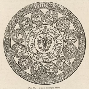
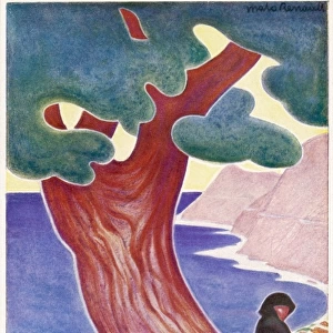
World Map / Arab Abu Ishak
An Arab map of the world, showing deserts and water
Mary Evans Picture Library makes available wonderful images created for people to enjoy over the centuries
Media ID 608723
© Mary Evans Picture Library 2015 - https://copyrighthub.org/s0/hub1/creation/maryevans/MaryEvansPictureID/10113650
16"x16" Premium Frame
Contemporary style Premium Wooden Frame with 10"x10" Print. Complete with 2" White Mat and 1.25" thick MDF frame. Printed on 260 gsm premium paper. Glazed with shatter proof UV coated acrylic glass. Backing is paper covered backing with rubber bumpers. Supplied ready to hang with a pre-installed sawtooth/wire hanger. Care Instructions: Spot clean with a damp cloth. Securely packaged in a clear plastic bag and envelope in a reinforced cardboard shipper
FSC Real Wood Frame and Double Mounted with White Conservation Mountboard - Professionally Made and Ready to Hang
Estimated Image Size (if not cropped) is 25.4cm x 25.4cm (10" x 10")
Estimated Product Size is 40.6cm x 40.6cm (16" x 16")
These are individually made so all sizes are approximate
Artwork printed orientated as per the preview above, with landscape (horizontal) or portrait (vertical) orientation to match the source image.
EDITORS COMMENTS
This stunning print of the "World Map / Arab Abu Ishak" from Mary Evans Picture Library offers a fascinating glimpse into history. Dating back to 950 AD, this Arab map of the world showcases intricate details of deserts and water bodies, providing a unique perspective on how ancient civilizations viewed geography.
The map is not only a visual representation of the world but also serves as a historical artifact that sheds light on the knowledge and technology available during that time period. The precision and accuracy with which the deserts and water are depicted demonstrate the advanced cartographic skills possessed by Arab scholars in the 10th century.
As we gaze upon this remarkable piece of art, we are transported back in time to an era where exploration and discovery were at the forefront of human endeavors. The intricate patterns and symbols used to denote different geographical features evoke a sense of wonder and curiosity about our planet's vast landscapes.
Mary Evans Prints Online has curated an exceptional collection that allows us to appreciate the beauty and complexity of maps like these. This particular print serves as a reminder of how interconnected our world truly is, despite being separated by vast oceans and expansive deserts. It is a testament to human ingenuity and creativity that continues to inspire us today.
MADE IN THE USA
Safe Shipping with 30 Day Money Back Guarantee
FREE PERSONALISATION*
We are proud to offer a range of customisation features including Personalised Captions, Color Filters and Picture Zoom Tools
SECURE PAYMENTS
We happily accept a wide range of payment options so you can pay for the things you need in the way that is most convenient for you
* Options may vary by product and licensing agreement. Zoomed Pictures can be adjusted in the Cart.