Premium Framed Print > Europe > Russia > Maps
Premium Framed Print : MAP / NORTH AMERICA C1800


![]()
Framed Photos From Mary Evans Picture Library
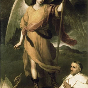
MAP / NORTH AMERICA C1800
A fascinating map of North America, from the Russian settlements in the NW via the territory of the Long-Hair Indians to New Albion and Tecas (sic) Date: circa 1800
Mary Evans Picture Library makes available wonderful images created for people to enjoy over the centuries
Media ID 20147069
© Bubblepunk
1800 Albion C1800 Fascinating Indians Maps Settlements Territory
14"x16" Premium Frame
Contemporary style Premium Wooden Frame with 8"x10" Print. Complete with 2" White Mat and 1.25" thick MDF frame. Printed on 260 gsm premium paper. Glazed with shatter proof UV coated acrylic glass. Backing is paper covered backing with rubber bumpers. Supplied ready to hang with a pre-installed sawtooth/wire hanger. Care Instructions: Spot clean with a damp cloth. Securely packaged in a clear plastic bag and envelope in a reinforced cardboard shipper
FSC Real Wood Frame and Double Mounted with White Conservation Mountboard - Professionally Made and Ready to Hang
Estimated Image Size (if not cropped) is 20.3cm x 25.4cm (8" x 10")
Estimated Product Size is 35.6cm x 40.6cm (14" x 16")
These are individually made so all sizes are approximate
Artwork printed orientated as per the preview above, with portrait (vertical) orientation to match the source image.
FEATURES IN THESE COLLECTIONS
> Mary Evans Prints Online
> America
> Mary Evans Prints Online
> New Images July 2020
> Europe
> Russia
> Related Images
> Maps and Charts
> Related Images
EDITORS COMMENTS
This map print, titled "North America," offers a glimpse into the intriguing cartographic record of the North American continent during the late 18th century. Dated circa 1800, the map showcases the expanding European knowledge of the New World, from the Russian settlements in the Northwest to the vast territories inhabited by the Long-Hair Indians. The map's intricate detailing reveals the exploratory spirit of the era, with exploratory routes, settlements, and territorial claims marked across the vast expanse of North America. Notable features include the Russian settlements along the North Pacific coast, the territory of the Long-Hair Indians, believed to be the present-day Great Plains region inhabited by various Native American tribes, and the intriguing designation of "New Albion" and "Tecas" in the Pacific Northwest. The map's title, "North America," is accompanied by a compass rose and an inset map of the Caribbean, further emphasizing the comprehensive nature of the cartographic representation. The map's labeling of various geographical features, such as rivers, mountains, and bodies of water, is a testament to the extensive research and exploration that had taken place during this period. The "North America" map print is a fascinating historical artifact, providing valuable insights into the geographic knowledge of the New World during the late 18th century. Its intricate detailing and captivating design make it an essential addition to any collection of historical maps or cartographic prints.
MADE IN THE USA
Safe Shipping with 30 Day Money Back Guarantee
FREE PERSONALISATION*
We are proud to offer a range of customisation features including Personalised Captions, Color Filters and Picture Zoom Tools
SECURE PAYMENTS
We happily accept a wide range of payment options so you can pay for the things you need in the way that is most convenient for you
* Options may vary by product and licensing agreement. Zoomed Pictures can be adjusted in the Basket.