Premium Framed Print > Historic > World War I and II > World War II
Premium Framed Print : Map showing the distances between cities 1939


![]()
Framed Photos from Mary Evans Picture Library
Map showing the distances between cities 1939
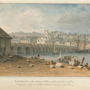
Map showing the distance from Moscow, Danzig, Warsaw, Berlin and Venice in relation to London in order to highlight the likelihood of air raids.
1939
Mary Evans Picture Library makes available wonderful images created for people to enjoy over the centuries
Media ID 23269054
© Illustrated London News Ltd/Mary Evans
Attack Attacks Berlin Danzig Distance Distances Jul19 Maps Moscow Raid Raids Venice Warsaw
14"x18" Premium Frame
Contemporary style Premium Wooden Frame with 8"x12" Print. Complete with 2" White Mat and 1.25" thick MDF frame. Printed on 260 gsm premium paper. Glazed with shatter proof UV coated acrylic glass. Backing is paper covered backing with rubber bumpers. Supplied ready to hang with a pre-installed sawtooth/wire hanger. Care Instructions: Spot clean with a damp cloth. Securely packaged in a clear plastic bag and envelope in a reinforced cardboard shipper
FSC Real Wood Frame and Double Mounted with White Conservation Mountboard - Professionally Made and Ready to Hang
Estimated Image Size (if not cropped) is 30.4cm x 20.3cm (12" x 8")
Estimated Product Size is 45.8cm x 35.6cm (18" x 14")
These are individually made so all sizes are approximate
Artwork printed orientated as per the preview above, with landscape (horizontal) orientation to match the source image.
FEATURES IN THESE COLLECTIONS
> Mary Evans Prints Online
> New Images August 2021
> Historic
> World War I and II
> World War II
> Maps and Charts
> Related Images
> Maps and Charts
> World
EDITORS COMMENTS
This historic map, published by the Illustrated London News Ltd in July 1939, provides a stark illustration of the distances between major European cities and London during the onset of World War II. The map highlights the proximity of key cities, including Moscow, Danzig, Warsaw, Berlin, and Venice, to the British capital, underscoring the likelihood of air raids as tensions between European powers escalated. The map serves as a poignant reminder of the geopolitical landscape of Europe on the brink of conflict. Moscow, the capital of the Soviet Union, was located over 1,500 miles (2,400 kilometers) east of London, while Danzig, a free city located at the mouth of the Vistula River, was only 700 miles (1,100 kilometers) away. Warsaw, the capital of Poland, was similarly close, just under 800 miles (1,300 kilometers) from London. Berlin, the capital of Nazi Germany, was approximately 850 miles (1,370 kilometers) to the southwest. Venice, an Italian city on the Adriatic Sea, was over 1,000 miles (1,600 kilometers) to the south. The proximity of these cities to London, particularly those under the control of aggressive and expansionist regimes, heightened the sense of urgency and vulnerability felt by the British people as the threat of air raids loomed. This map offers a glimpse into the geopolitical realities of the time, providing valuable context to the events leading up to the outbreak of the Second World War.
MADE IN THE USA
Safe Shipping with 30 Day Money Back Guarantee
FREE PERSONALISATION*
We are proud to offer a range of customisation features including Personalised Captions, Color Filters and Picture Zoom Tools
SECURE PAYMENTS
We happily accept a wide range of payment options so you can pay for the things you need in the way that is most convenient for you
* Options may vary by product and licensing agreement. Zoomed Pictures can be adjusted in the Cart.