Premium Framed Print > Europe > United Kingdom > Wales > Maps
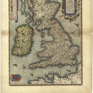
Premium Framed Print : Map / England & Wales 1810


![]()
Framed Photos from Mary Evans Picture Library
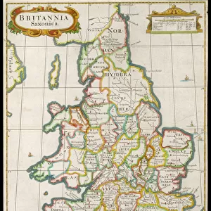
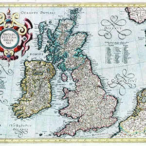
Map / England & Wales 1810
England and Wales
Mary Evans Picture Library makes available wonderful images created for people to enjoy over the centuries
Media ID 573979
© Mary Evans Picture Library 2015 - https://copyrighthub.org/s0/hub1/creation/maryevans/MaryEvansPictureID/10009511
14"x16" Premium Frame
Contemporary style Premium Wooden Frame with 8"x10" Print. Complete with 2" White Mat and 1.25" thick MDF frame. Printed on 260 gsm premium paper. Glazed with shatter proof UV coated acrylic glass. Backing is paper covered backing with rubber bumpers. Supplied ready to hang with a pre-installed sawtooth/wire hanger. Care Instructions: Spot clean with a damp cloth. Securely packaged in a clear plastic bag and envelope in a reinforced cardboard shipper
FSC Real Wood Frame and Double Mounted with White Conservation Mountboard - Professionally Made and Ready to Hang
Estimated Image Size (if not cropped) is 25.4cm x 20.3cm (10" x 8")
Estimated Product Size is 40.6cm x 35.6cm (16" x 14")
These are individually made so all sizes are approximate
Artwork printed orientated as per the preview above, with landscape (horizontal) orientation to match the source image.
FEATURES IN THESE COLLECTIONS
> Mary Evans Prints Online
> Maps
> Europe
> United Kingdom
> England
> Maps
> Europe
> United Kingdom
> England
> Posters
> Europe
> United Kingdom
> England
> Related Images
> Europe
> United Kingdom
> Wales
> Maps
> Europe
> United Kingdom
> Wales
> Posters
> Europe
> United Kingdom
> Wales
> Related Images
> Maps and Charts
> Early Maps
> Maps and Charts
> Related Images
> Maps and Charts
> Wales
EDITORS COMMENTS
This map print, titled "England and Wales," dates back to the year 1810 and offers a fascinating glimpse into the historical geography of Britain during that era. Published during the Regency period, this map meticulously depicts the political boundaries and topographical features of England and Wales at the time. The map is adorned with intricate detail, revealing the counties, cities, towns, and villages that dotted the English and Welsh landscapes over two centuries ago. The River Thames, the Severn Estuary, and other major waterways are clearly marked, as are important roads and transportation routes. The border between England and Wales is distinctly demarcated, reflecting the political and cultural divide between the two countries. The map also includes a rich array of annotations and symbols, denoting various features such as coal mines, forests, and ancient monuments. The historical significance of this map is immense, as it provides valuable insight into the geographical and political landscape of England and Wales during a pivotal period in their shared history. The map's intricate detail and antique charm make it a captivating addition to any historical or cartographical collection. This map print, from the Mary Evans Picture Library, is a testament to the rich history and cultural heritage of England and Wales. Its intricate detail and historical accuracy make it an invaluable resource for scholars, historians, and anyone with an interest in the history of the British Isles. Whether displayed as a decorative piece or used for research purposes, this map print is sure to inspire wonder and fascination for generations to come.
MADE IN THE USA
Safe Shipping with 30 Day Money Back Guarantee
FREE PERSONALISATION*
We are proud to offer a range of customisation features including Personalised Captions, Color Filters and Picture Zoom Tools
SECURE PAYMENTS
We happily accept a wide range of payment options so you can pay for the things you need in the way that is most convenient for you
* Options may vary by product and licensing agreement. Zoomed Pictures can be adjusted in the Cart.