Premium Framed Print > Europe > United Kingdom > England > Maps
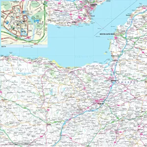
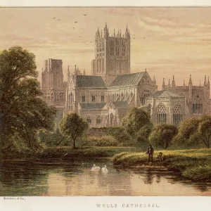
Premium Framed Print : Map / Somerset C1857


![]()
Framed Photos from Mary Evans Picture Library
Map / Somerset C1857
Map of Somerset
Mary Evans Picture Library makes available wonderful images created for people to enjoy over the centuries
Media ID 4357725
© Mary Evans Picture Library 2015 - https://copyrighthub.org/s0/hub1/creation/maryevans/MaryEvansPictureID/10113997
14"x16" Premium Frame
Contemporary style Premium Wooden Frame with 8"x10" Print. Complete with 2" White Mat and 1.25" thick MDF frame. Printed on 260 gsm premium paper. Glazed with shatter proof UV coated acrylic glass. Backing is paper covered backing with rubber bumpers. Supplied ready to hang with a pre-installed sawtooth/wire hanger. Care Instructions: Spot clean with a damp cloth. Securely packaged in a clear plastic bag and envelope in a reinforced cardboard shipper
FSC Real Wood Frame and Double Mounted with White Conservation Mountboard - Professionally Made and Ready to Hang
Estimated Image Size (if not cropped) is 25.4cm x 20.3cm (10" x 8")
Estimated Product Size is 40.6cm x 35.6cm (16" x 14")
These are individually made so all sizes are approximate
Artwork printed orientated as per the preview above, with landscape (horizontal) orientation to match the source image.
FEATURES IN THESE COLLECTIONS
> Europe
> United Kingdom
> England
> Maps
> Europe
> United Kingdom
> England
> Posters
> Europe
> United Kingdom
> England
> Related Images
> Europe
> United Kingdom
> England
> Somerset
> Related Images
> Maps and Charts
> Early Maps
> Maps and Charts
> Related Images
EDITORS COMMENTS
This print of a map of Somerset from 1857 offers a fascinating glimpse into the history and geography of this beautiful English county. The intricate details and delicate lines on the map showcase the craftsmanship and precision that went into creating such an important historical document.
As we study this map, we can imagine what life was like in Somerset over 150 years ago. The towns, villages, rivers, and roads depicted on the map give us a sense of how people lived and traveled during that time period. It's almost like taking a step back in time to explore the landscape as it once was.
The rich history of Somerset is evident in every corner of this map, with each place name telling its own story. From bustling market towns to quiet rural hamlets, each location has its own unique character that adds to the charm of this historic document.
Whether you're a history buff, a lover of maps, or simply someone who appreciates fine artistry, this print is sure to capture your imagination. Display it proudly in your home or office as a conversation piece that will spark curiosity and admiration from all who see it.
Step into the past with this stunning print of Somerset from 1857 - a true treasure for anyone interested in exploring England's rich heritage through cartography.
MADE IN THE USA
Safe Shipping with 30 Day Money Back Guarantee
FREE PERSONALISATION*
We are proud to offer a range of customisation features including Personalised Captions, Color Filters and Picture Zoom Tools
SECURE PAYMENTS
We happily accept a wide range of payment options so you can pay for the things you need in the way that is most convenient for you
* Options may vary by product and licensing agreement. Zoomed Pictures can be adjusted in the Cart.