Premium Framed Print > Maps and Charts > Early Maps
Premium Framed Print : 1815 Europe Map


![]()
Framed Photos from Mary Evans Picture Library
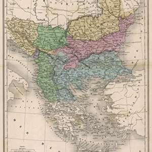
1815 Europe Map
A map of Europe at the time of the Congress of Vienna
Mary Evans Picture Library makes available wonderful images created for people to enjoy over the centuries
Media ID 4369271
© Mary Evans Picture Library 2015 - https://copyrighthub.org/s0/hub1/creation/maryevans/MaryEvansPictureID/10124947
1815 Congress Maps Treaty Vienna
14"x18" Premium Frame
Contemporary style Premium Wooden Frame with 8"x12" Print. Complete with 2" White Mat and 1.25" thick MDF frame. Printed on 260 gsm premium paper. Glazed with shatter proof UV coated acrylic glass. Backing is paper covered backing with rubber bumpers. Supplied ready to hang with a pre-installed sawtooth/wire hanger. Care Instructions: Spot clean with a damp cloth. Securely packaged in a clear plastic bag and envelope in a reinforced cardboard shipper
FSC Real Wood Frame and Double Mounted with White Conservation Mountboard - Professionally Made and Ready to Hang
Estimated Image Size (if not cropped) is 30.4cm x 20.3cm (12" x 8")
Estimated Product Size is 45.8cm x 35.6cm (18" x 14")
These are individually made so all sizes are approximate
Artwork printed orientated as per the preview above, with landscape (horizontal) orientation to match the source image.
FEATURES IN THESE COLLECTIONS
> Europe
> Related Images
> Maps and Charts
> Early Maps
> Maps and Charts
> Related Images
EDITORS COMMENTS
This stunning print captures a detailed map of Europe as it appeared in the year 1815, during the time of the Congress of Vienna. The Congress of Vienna was a significant event in European history, where major powers came together to redraw the political boundaries following the defeat of Napoleon Bonaparte. This map provides a fascinating glimpse into the geopolitical landscape of Europe at that pivotal moment.
The intricate details on this map showcase not only the various countries and regions within Europe, but also highlight important cities, rivers, and mountain ranges. It serves as a valuable historical document that sheds light on how borders were defined and territories were divided during this crucial period.
As we study this map, we can imagine diplomats and statesmen poring over similar documents during negotiations at the Congress of Vienna. The treaties signed during this time would have far-reaching consequences for generations to come, shaping alliances and conflicts throughout Europe.
Whether you are a history buff or simply appreciate beautiful cartography, this print is sure to captivate your imagination and transport you back to 1815 Europe. Display it proudly in your home or office as a reminder of an era when nations came together to shape the future of our continent.
MADE IN THE USA
Safe Shipping with 30 Day Money Back Guarantee
FREE PERSONALISATION*
We are proud to offer a range of customisation features including Personalised Captions, Color Filters and Picture Zoom Tools
SECURE PAYMENTS
We happily accept a wide range of payment options so you can pay for the things you need in the way that is most convenient for you
* Options may vary by product and licensing agreement. Zoomed Pictures can be adjusted in the Cart.