Premium Framed Print > Arts > Artists > O > John Ogilby
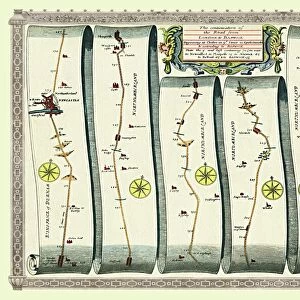
Premium Framed Print : Old Road Strip Map (PLATE 6) The Continuation of the Road from London to Barwick
 The Continuation of the Road from London to Barwick")

 The Continuation of the Road from London to Barwick")


![]()
Framed Photos From MapSeeker
Old Road Strip Map (PLATE 6) The Continuation of the Road from London to Barwick
OLG006
Welcome to the Mapseeker Image library and enter an historic gateway to one of the largest on-line collections of Historic Maps, Nostalgic Views, Vista's and Panorama's from a World gone by.
Media ID 20347297
John Ogilby Ogilby Old Road Strip Map Strip Map
14"x18" Premium Frame
Contemporary style Premium Wooden Frame with 8"x12" Print. Complete with 2" White Mat and 1.25" thick MDF frame. Printed on 260 gsm premium paper. Glazed with shatter proof UV coated acrylic glass. Backing is paper covered backing with rubber bumpers. Supplied ready to hang with a pre-installed sawtooth/wire hanger. Care Instructions: Spot clean with a damp cloth. Securely packaged in a clear plastic bag and envelope in a reinforced cardboard shipper
FSC Real Wood Frame and Double Mounted with White Conservation Mountboard - Professionally Made and Ready to Hang
Estimated Image Size (if not cropped) is 30.4cm x 20.3cm (12" x 8")
Estimated Product Size is 45.8cm x 35.6cm (18" x 14")
These are individually made so all sizes are approximate
Artwork printed orientated as per the preview above, with landscape (horizontal) orientation to match the source image.
EDITORS COMMENTS
Caption: The Old Road Strip Map (PLATE 6) captures a fascinating glimpse into the past, showcasing the continuation of the road from London to Barwick. This meticulously detailed strip map, created by renowned cartographer John Ogilby, offers an invaluable historical record of one of England's most important routes during the 17th century. As we delve into this print from MapSeeker, we are transported back in time to an era when travel was arduous and journeys were measured in days rather than hours. The intricately illustrated map reveals every twist and turn along this vital thoroughfare, allowing us to trace the footsteps of countless travelers who once traversed these very roads. Ogilby's expertise shines through as he masterfully depicts not only major towns and villages but also smaller settlements that dotted the landscape. Each landmark is carefully labeled with precise distances between them, providing a sense of scale and perspective for those embarking on their own adventures or simply curious about life in centuries past. This particular plate showcases Plate 6 of Ogilby's comprehensive survey, highlighting his dedication to accuracy and attention to detail. It serves as a testament to his commitment towards creating reliable maps for both practical use and scholarly study. Whether you are a history enthusiast or simply intrigued by cartography, this old road strip map offers a captivating window into England's rich heritage while reminding us how far transportation has evolved since its creation.
MADE IN THE USA
Safe Shipping with 30 Day Money Back Guarantee
FREE PERSONALISATION*
We are proud to offer a range of customisation features including Personalised Captions, Color Filters and Picture Zoom Tools
SECURE PAYMENTS
We happily accept a wide range of payment options so you can pay for the things you need in the way that is most convenient for you
* Options may vary by product and licensing agreement. Zoomed Pictures can be adjusted in the Basket.