Premium Framed Print > Arts > Artists > T > John Tallis
Premium Framed Print : Old Map of Egypt and Arabia Petraea 1851 by John Tallis


![]()
Framed Photos from MapSeeker
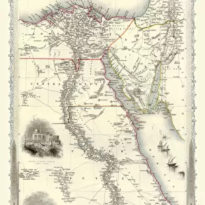
Old Map of Egypt and Arabia Petraea 1851 by John Tallis
A fine facimile artworked from an antique original map of Egypt and Arabia Petraea, issued as part of the 1851 edition of John Tallis and Companys " The Illustrated Atlas and Modern History of the World"
Welcome to the Mapseeker Image library and enter an historic gateway to one of the largest on-line collections of Historic Maps, Nostalgic Views, Vista's and Panorama's from a World gone by.
Media ID 20347664
© Mapseeker Publishing Ltd
John Tallis John Tallis Map Tallis Map
14"x18" Premium Frame
Contemporary style Premium Wooden Frame with 8"x12" Print. Complete with 2" White Mat and 1.25" thick MDF frame. Printed on 260 gsm premium paper. Glazed with shatter proof UV coated acrylic glass. Backing is paper covered backing with rubber bumpers. Supplied ready to hang with a pre-installed sawtooth/wire hanger. Care Instructions: Spot clean with a damp cloth. Securely packaged in a clear plastic bag and envelope in a reinforced cardboard shipper
FSC Real Wood Frame and Double Mounted with White Conservation Mountboard - Professionally Made and Ready to Hang
Estimated Image Size (if not cropped) is 20.3cm x 30.4cm (8" x 12")
Estimated Product Size is 35.6cm x 45.8cm (14" x 18")
These are individually made so all sizes are approximate
Artwork printed orientated as per the preview above, with portrait (vertical) orientation to match the source image.
FEATURES IN THESE COLLECTIONS
> MapSeeker
> Maps of Asia and Middle East
> Maps of the Middle East and East Indies
> Africa
> Egypt
> Related Images
> Arts
> Artists
> T
> John Tallis
> Maps and Charts
> World
EDITORS COMMENTS
This print showcases the "Old Map of Egypt and Arabia Petraea 1851" by John Tallis, a renowned cartographer of his time. This fine facsimile artwork is meticulously reproduced from an antique original map, which was originally issued as part of the 1851 edition of John Tallis and Company's "The Illustrated Atlas and Modern History of the World". Transporting us back in time, this map offers a glimpse into the rich history and geography of Egypt and Arabia Petraea during the mid-19th century. With intricate details and exquisite craftsmanship, it captures both the artistry and accuracy that made Tallis maps highly sought after. As we explore this old map, we can marvel at its depiction of ancient cities like Cairo, Alexandria, Luxor, and Thebes. It also highlights significant landmarks such as the Nile River winding through lush landscapes dotted with pyramids. The borders are adorned with ornate illustrations showcasing local flora, fauna, historical figures, and cultural symbols. John Tallis collaborated with talented engraver John Rapkin to create this masterpiece that not only serves as a geographical reference but also evokes a sense of wonderment for those who appreciate cartographic artistry. Whether you are an avid historian or simply captivated by vintage maps, this print transports you to another era while celebrating the timeless beauty found within these historic documents.
MADE IN THE USA
Safe Shipping with 30 Day Money Back Guarantee
FREE PERSONALISATION*
We are proud to offer a range of customisation features including Personalised Captions, Color Filters and Picture Zoom Tools
SECURE PAYMENTS
We happily accept a wide range of payment options so you can pay for the things you need in the way that is most convenient for you
* Options may vary by product and licensing agreement. Zoomed Pictures can be adjusted in the Cart.