Premium Framed Print > Arts > Artists > M > Thomas Moule
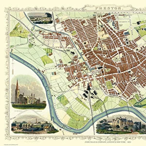
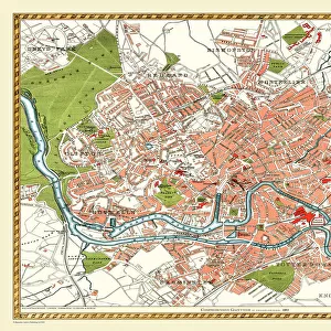
Premium Framed Print : Old Map of Preston 1824 by Edward Baines


![]()
Framed Photos from MapSeeker
Old Map of Preston 1824 by Edward Baines
This is a fine detailed reproduction Map of The City of Preston from the First Edition series of Thomas Moule Maps, originally Published in 1836
Welcome to the Mapseeker Image library and enter an historic gateway to one of the largest on-line collections of Historic Maps, Nostalgic Views, Vista's and Panorama's from a World gone by.
Media ID 20347249
Historic Map Old Town Plan Edward Baines Preston
14"x18" Premium Frame
Contemporary style Premium Wooden Frame with 8"x12" Print. Complete with 2" White Mat and 1.25" thick MDF frame. Printed on 260 gsm premium paper. Glazed with shatter proof UV coated acrylic glass. Backing is paper covered backing with rubber bumpers. Supplied ready to hang with a pre-installed sawtooth/wire hanger. Care Instructions: Spot clean with a damp cloth. Securely packaged in a clear plastic bag and envelope in a reinforced cardboard shipper
FSC Real Wood Frame and Double Mounted with White Conservation Mountboard - Professionally Made and Ready to Hang
Estimated Image Size (if not cropped) is 30.4cm x 20.3cm (12" x 8")
Estimated Product Size is 45.8cm x 35.6cm (18" x 14")
These are individually made so all sizes are approximate
Artwork printed orientated as per the preview above, with landscape (horizontal) orientation to match the source image.
FEATURES IN THESE COLLECTIONS
> MapSeeker
> British Town And City Plans
> English & Welsh PORTFOLIO
> Arts
> Artists
> B
> Thomas Baines
> Arts
> Artists
> M
> Thomas Moule
> Arts
> Photorealistic artworks
> Detailed art pieces
> Masterful detailing in art
> Maps and Charts
> Related Images
EDITORS COMMENTS
This exquisite print showcases the "Old Map of Preston 1824" by Edward Baines, a renowned cartographer of his time. This fine reproduction is part of the esteemed First Edition series of Thomas Moule Maps, originally published in 1836. Capturing every intricate detail, this map offers a fascinating glimpse into the city's rich history and development during the early 19th century. The meticulously drawn streets, landmarks, and buildings provide an authentic representation of Preston's urban landscape at that time. As you explore this vintage treasure, you can trace the winding paths along the River Ribble and discover how they shaped the city's growth over centuries. From its bustling marketplaces to its grand churches and historic structures, this map allows you to immerse yourself in Preston's past. Edward Baines' expertise as a cartographer shines through in this remarkable piece. His dedication to accuracy ensures that each street corner and alleyway is faithfully depicted on this beautifully preserved print. Whether you are a history enthusiast or simply curious about your hometown's roots, this old map of Preston will transport you back in time. It serves as both a captivating decorative piece for your home or office space and an invaluable resource for researchers delving into Preston's vibrant heritage
MADE IN THE USA
Safe Shipping with 30 Day Money Back Guarantee
FREE PERSONALISATION*
We are proud to offer a range of customisation features including Personalised Captions, Color Filters and Picture Zoom Tools
SECURE PAYMENTS
We happily accept a wide range of payment options so you can pay for the things you need in the way that is most convenient for you
* Options may vary by product and licensing agreement. Zoomed Pictures can be adjusted in the Cart.