Premium Framed Print > Europe > United Kingdom > England > Bristol > Bristol
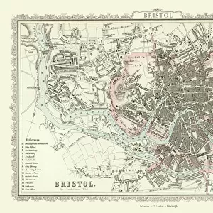
Premium Framed Print : Old Map of Bristol 1903


![]()
Framed Photos from MapSeeker
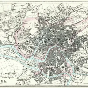
Old Map of Bristol 1903
J104
Welcome to the Mapseeker Image library and enter an historic gateway to one of the largest on-line collections of Historic Maps, Nostalgic Views, Vista's and Panorama's from a World gone by.
Media ID 20347140
Historic Map Old Town Plan Bristol Bristol City
14"x18" Premium Frame
Contemporary style Premium Wooden Frame with 8"x12" Print. Complete with 2" White Mat and 1.25" thick MDF frame. Printed on 260 gsm premium paper. Glazed with shatter proof UV coated acrylic glass. Backing is paper covered backing with rubber bumpers. Supplied ready to hang with a pre-installed sawtooth/wire hanger. Care Instructions: Spot clean with a damp cloth. Securely packaged in a clear plastic bag and envelope in a reinforced cardboard shipper
FSC Real Wood Frame and Double Mounted with White Conservation Mountboard - Professionally Made and Ready to Hang
Estimated Image Size (if not cropped) is 30.4cm x 20.3cm (12" x 8")
Estimated Product Size is 45.8cm x 35.6cm (18" x 14")
These are individually made so all sizes are approximate
Artwork printed orientated as per the preview above, with landscape (horizontal) orientation to match the source image.
FEATURES IN THESE COLLECTIONS
> MapSeeker
> British Town And City Plans
> English & Welsh PORTFOLIO
> Europe
> United Kingdom
> England
> Bristol
> Bristol
> Maps and Charts
> Related Images
EDITORS COMMENTS
This print showcases an exquisite piece of history, the "Old Map of Bristol 1903 (J104)". Transporting us back in time to the early 20th century, this map offers a fascinating glimpse into the intricate layout and charm of Bristol. With its detailed cartography and delicate craftsmanship, it serves as a testament to the artistry and precision of mapmaking during that era. The town plan depicted on this historic map reveals Bristol's rich heritage and urban development at the turn of the century. Every street, building, and landmark is meticulously illustrated, allowing us to trace our fingers along its winding roads and bustling city center. It evokes a sense of nostalgia for a bygone era when horse-drawn carriages traversed these streets. As we examine this old town plan closely, we can't help but marvel at how much has changed over time while also appreciating what remains constant. The familiar landmarks such as St Mary Redcliffe Church or Clifton Suspension Bridge remind us that despite progress and modernization, some elements endure as symbols of continuity in Bristol's ever-evolving landscape. Whether you are an avid historian or simply captivated by vintage aesthetics, this print is sure to be a cherished addition to any collection. Its timeless appeal transcends generations while offering an immersive experience into Bristol's past. Let it transport you through time as you explore every intricacy etched onto its surface – truly capturing the essence of this remarkable city.
MADE IN THE USA
Safe Shipping with 30 Day Money Back Guarantee
FREE PERSONALISATION*
We are proud to offer a range of customisation features including Personalised Captions, Color Filters and Picture Zoom Tools
SECURE PAYMENTS
We happily accept a wide range of payment options so you can pay for the things you need in the way that is most convenient for you
* Options may vary by product and licensing agreement. Zoomed Pictures can be adjusted in the Cart.