Premium Framed Print > Animals > Reptiles > Snakes > Viper > River Jack
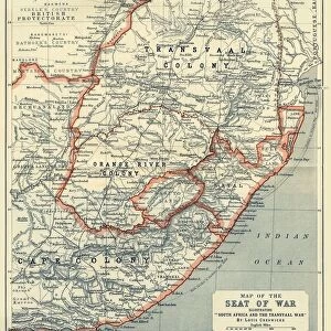
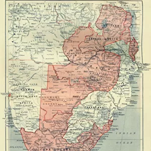
Premium Framed Print : Map Illustrating the Operations on the South of the Orange River, 1900. Creator: Unknown


![]()
Framed Photos From Heritage Images
Map Illustrating the Operations on the South of the Orange River, 1900. Creator: Unknown
Map Illustrating the Operations on the South of the Orange River, 1900. From " South Africa and the Transvaal War, Vol. II", by Louis Creswicke. [T. C. & E. C. Jack, Edinburgh, 1900]
Heritage Images features heritage image collections
Media ID 19779057
© The Print Collector/Heritage Images
Cartography Creswicke Jack Louis Louis Creswicke Map Making Mapmaking Orange Free State South Africa South Africa And The Transvaal War Tc And Ec Tc And Ec Jack
14"x16" Premium Frame
Contemporary style Premium Wooden Frame with 8"x10" Print. Complete with 2" White Mat and 1.25" thick MDF frame. Printed on 260 gsm premium paper. Glazed with shatter proof UV coated acrylic glass. Backing is paper covered backing with rubber bumpers. Supplied ready to hang with a pre-installed sawtooth/wire hanger. Care Instructions: Spot clean with a damp cloth. Securely packaged in a clear plastic bag and envelope in a reinforced cardboard shipper
FSC Real Wood Frame and Double Mounted with White Conservation Mountboard - Professionally Made and Ready to Hang
Estimated Image Size (if not cropped) is 25.4cm x 20.3cm (10" x 8")
Estimated Product Size is 40.6cm x 35.6cm (16" x 14")
These are individually made so all sizes are approximate
Artwork printed orientated as per the preview above, with landscape (horizontal) orientation to match the source image.
FEATURES IN THESE COLLECTIONS
> Africa
> South Africa
> Maps
> Africa
> South Africa
> Related Images
> Animals
> Reptiles
> Snakes
> River Jack
> Animals
> Reptiles
> Snakes
> Viper
> River Jack
> Arts
> Literature
> Illustration
> Arts
> Literature
> Europe
> United Kingdom
> Scotland
> Edinburgh
> Edinburgh
> Europe
> United Kingdom
> Scotland
> Lothian
> Edinburgh
> Maps and Charts
> Related Images
EDITORS COMMENTS
This print showcases a historical map titled "Map Illustrating the Operations on the South of the Orange River, 1900". Created by an unknown artist and featured in Louis Creswicke's book "South Africa and the Transvaal War, Vol. II" this map provides a fascinating glimpse into the geography and cartography of South Africa during the late 19th century. The intricate details depicted on this map highlight various locations within South Africa, including the Orange Free State. As one explores this visual representation of African terrain, it becomes evident that it serves as more than just a geographical reference; it also offers insights into military operations conducted during that time period. With its rich history and cultural significance, this map print is not only a work of art but also an invaluable resource for those interested in understanding South Africa's past. The collaboration between Louis Creswicke and T. C. & E. C. Jack resulted in a masterpiece that seamlessly combines literature with cartography. As we delve deeper into this image from Heritage Images, we are transported back to early 20th-century South Africa—a time when exploration and discovery were at their peak. This print serves as a reminder of how maps have played an essential role in shaping our understanding of countries, continents, and even entire civilizations throughout history.
MADE IN THE USA
Safe Shipping with 30 Day Money Back Guarantee
FREE PERSONALISATION*
We are proud to offer a range of customisation features including Personalised Captions, Color Filters and Picture Zoom Tools
SECURE PAYMENTS
We happily accept a wide range of payment options so you can pay for the things you need in the way that is most convenient for you
* Options may vary by product and licensing agreement. Zoomed Pictures can be adjusted in the Basket.