Premium Framed Print > Europe > France > Maps
Premium Framed Print : The Dauphin Map of the World, (1546), 1912. Artist: Pierre Desceliers
, 1912. Artist: Pierre Desceliers")
, 1912. Artist: Pierre Desceliers")


![]()
Framed Photos From Heritage Images
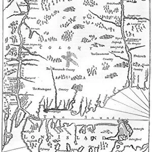
The Dauphin Map of the World, (1546), 1912. Artist: Pierre Desceliers
The Dauphin Map of the World, 1546. After Pierre Desceliers, (c1500-1558) Planisphere which is sometimes refered to as the Dauphin Map. The map was created for King Henri II of France (1519-1559). Taken from A Book of Discovery, published by T. C. & E. C. Jack Ltd. 1912
Heritage Images features heritage image collections
Media ID 14959384
© The Print Collector
Cartography Colourful Discovery Exploration Henri Ii Henry Ii Jack King Of France Map Making Pierre Tc And Ec Tc And Ec Jack World Map Planisphere
14"x18" Premium Frame
Contemporary style Premium Wooden Frame with 8"x12" Print. Complete with 2" White Mat and 1.25" thick MDF frame. Printed on 260 gsm premium paper. Glazed with shatter proof UV coated acrylic glass. Backing is paper covered backing with rubber bumpers. Supplied ready to hang with a pre-installed sawtooth/wire hanger. Care Instructions: Spot clean with a damp cloth. Securely packaged in a clear plastic bag and envelope in a reinforced cardboard shipper
FSC Real Wood Frame and Double Mounted with White Conservation Mountboard - Professionally Made and Ready to Hang
Estimated Image Size (if not cropped) is 30.4cm x 20.3cm (12" x 8")
Estimated Product Size is 45.8cm x 35.6cm (18" x 14")
These are individually made so all sizes are approximate
Artwork printed orientated as per the preview above, with landscape (horizontal) orientation to match the source image.
FEATURES IN THESE COLLECTIONS
> Maps and Charts
> Related Images
> Maps and Charts
> World
EDITORS COMMENTS
This close-up of "The Dauphin Map of the World" takes us back to the 16th century, a time when exploration and discovery were at their peak. Created by Pierre Desceliers for King Henri II of France, this vibrant planisphere showcases the remarkable artistry and skill involved in mapmaking during that era. Every inch of this colorful map is filled with intricate details, depicting various continents, oceans, and even mythical creatures. It serves as a testament to humanity's thirst for knowledge and desire to understand the world beyond our own borders. As we gaze upon this print from 1912, we can't help but be transported to an age where cartography was not only about navigation but also about imagination. The meticulous craftsmanship displayed here reminds us of the dedication and precision required to create such masterpieces without modern technology. "The Dauphin Map" represents more than just geographical accuracy; it symbolizes mankind's unyielding spirit of exploration. It invites us to embark on a journey through history while marveling at the ingenuity that shaped our understanding of the world centuries ago. This photograph captures not only a piece of art but also an important chapter in human progress – a reminder that maps are not mere tools for direction but windows into our collective past.
MADE IN THE USA
Safe Shipping with 30 Day Money Back Guarantee
FREE PERSONALISATION*
We are proud to offer a range of customisation features including Personalised Captions, Color Filters and Picture Zoom Tools
SECURE PAYMENTS
We happily accept a wide range of payment options so you can pay for the things you need in the way that is most convenient for you
* Options may vary by product and licensing agreement. Zoomed Pictures can be adjusted in the Basket.