Premium Framed Print > Africa > Related Images
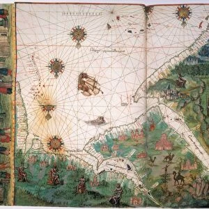
Premium Framed Print : MAP OF WEST AFRICA, c1547. From the Vallard Atlas; the map, drawn upside-down


![]()
Framed Photos From Granger
MAP OF WEST AFRICA, c1547. From the Vallard Atlas; the map, drawn upside-down
MAP OF WEST AFRICA, c1547.
From the Vallard Atlas; the map, drawn upside-down as if viewed from Europe, depicts the trading fortress of Sao Jorge da Mina on the African Gold Coast
Granger holds millions of images spanning more than 25,000 years of world history, from before the Stone Age to the dawn of the Space Age
Media ID 12321008
1547 African Castle Fort Portolan Chart Topography Trading Post Elmina Gulf Of Guinea
14"x16" Premium Frame
Contemporary style Premium Wooden Frame with 8"x10" Print. Complete with 2" White Mat and 1.25" thick MDF frame. Printed on 260 gsm premium paper. Glazed with shatter proof UV coated acrylic glass. Backing is paper covered backing with rubber bumpers. Supplied ready to hang with a pre-installed sawtooth/wire hanger. Care Instructions: Spot clean with a damp cloth. Securely packaged in a clear plastic bag and envelope in a reinforced cardboard shipper
FSC Real Wood Frame and Double Mounted with White Conservation Mountboard - Professionally Made and Ready to Hang
Estimated Image Size (if not cropped) is 25.4cm x 20.3cm (10" x 8")
Estimated Product Size is 40.6cm x 35.6cm (16" x 14")
These are individually made so all sizes are approximate
Artwork printed orientated as per the preview above, with landscape (horizontal) orientation to match the source image.
FEATURES IN THESE COLLECTIONS
> Granger Art on Demand
> Maps
> Africa
> Related Images
EDITORS COMMENTS
This print showcases a remarkable piece of history - the Map of West Africa from 1547. Taken from the Vallard Atlas, this map is drawn upside-down, providing a unique perspective as if viewed from Europe. The focal point of this ancient cartographic masterpiece is the trading fortress of Sao Jorge da Mina on the African Gold Coast. Transporting us back to the Renaissance era, this map offers insights into the intricate topography and trade routes that shaped West Africa during that time. With its detailed depiction of rivers, ports, and fortresses, it provides a glimpse into the bustling activity along the Gulf of Guinea. One cannot help but marvel at Elmina Castle's grandeur in this image. Serving as a vital trading post for European merchants seeking gold and other valuable resources, it stands tall against an expansive backdrop. Its exterior exudes strength and resilience while hinting at centuries-old stories waiting to be discovered within its walls. As we explore this historical gem captured by 140_1653721, we are reminded of how art can transport us through time and space. This print serves as both a visual delight and an educational tool for those curious about Africa's rich past and its significant role in global trade during one of history's most transformative periods.
MADE IN THE USA
Safe Shipping with 30 Day Money Back Guarantee
FREE PERSONALISATION*
We are proud to offer a range of customisation features including Personalised Captions, Color Filters and Picture Zoom Tools
SECURE PAYMENTS
We happily accept a wide range of payment options so you can pay for the things you need in the way that is most convenient for you
* Options may vary by product and licensing agreement. Zoomed Pictures can be adjusted in the Basket.