Premium Framed Print > Arts > Landscape paintings > Waterfall and river artworks > River artworks
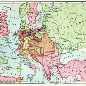
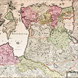
Premium Framed Print : MAP OF EUROPE, c1812. A 19th century German map of Europe during the reign of Napoleon I


![]()
Framed Photos from Granger
MAP OF EUROPE, c1812. A 19th century German map of Europe during the reign of Napoleon I
MAP OF EUROPE, c1812. A 19th century German map of Europe during the reign of Napoleon I, c1812
Granger holds millions of images spanning more than 25,000 years of world history, from before the Stone Age to the dawn of the Space Age
Media ID 6616223
1810s 1812 Bonaparte Europe First French Empire
14"x16" Premium Frame
Contemporary style Premium Wooden Frame with 8"x10" Print. Complete with 2" White Mat and 1.25" thick MDF frame. Printed on 260 gsm premium paper. Glazed with shatter proof UV coated acrylic glass. Backing is paper covered backing with rubber bumpers. Supplied ready to hang with a pre-installed sawtooth/wire hanger. Care Instructions: Spot clean with a damp cloth. Securely packaged in a clear plastic bag and envelope in a reinforced cardboard shipper
FSC Real Wood Frame and Double Mounted with White Conservation Mountboard - Professionally Made and Ready to Hang
Estimated Image Size (if not cropped) is 25.4cm x 20.3cm (10" x 8")
Estimated Product Size is 40.6cm x 35.6cm (16" x 14")
These are individually made so all sizes are approximate
Artwork printed orientated as per the preview above, with landscape (horizontal) orientation to match the source image.
FEATURES IN THESE COLLECTIONS
> Granger Art on Demand
> Maps
> Arts
> Landscape paintings
> Waterfall and river artworks
> River artworks
> Maps and Charts
> Early Maps
> Maps and Charts
> Related Images
EDITORS COMMENTS
This print showcases a remarkable piece of history - a 19th century German map of Europe, specifically depicting the region during the reign of Napoleon I in 1812. The intricate details and artistry captured in this print transport us back to a time when the first French Empire held sway over much of Europe. The map itself is an exquisite representation of its era, showcasing not only political boundaries but also highlighting major rivers that crisscrossed the continent. It serves as a testament to both the skill and precision with which cartographers worked during this period. As we gaze upon this historical artifact, we are reminded of the immense power wielded by Napoleon Bonaparte at his zenith. His influence extended far beyond France's borders, shaping the destiny of nations across Europe. This particular German map offers us insight into how European territories were organized under Napoleon's rule, providing valuable context for understanding geopolitical dynamics during that time. It serves as a visual reminder of an era marked by conflict and ambition, where empires rose and fell with each military campaign. Thanks to Granger Art on Demand's meticulous preservation efforts, we can now appreciate this stunning piece from our own homes. Whether you're an avid history enthusiast or simply captivated by vintage maps, this print is sure to spark curiosity and ignite your imagination about one of Europe's most transformative periods.
MADE IN THE USA
Safe Shipping with 30 Day Money Back Guarantee
FREE PERSONALISATION*
We are proud to offer a range of customisation features including Personalised Captions, Color Filters and Picture Zoom Tools
SECURE PAYMENTS
We happily accept a wide range of payment options so you can pay for the things you need in the way that is most convenient for you
* Options may vary by product and licensing agreement. Zoomed Pictures can be adjusted in the Cart.