Premium Framed Print > Maps and Charts > Early Maps
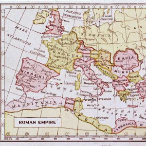
Premium Framed Print : MAP: EUROPE, 1920. Bacons Standard Map of Europe. Lithograph, 1920


![]()
Framed Photos From Granger
MAP: EUROPE, 1920. Bacons Standard Map of Europe. Lithograph, 1920
MAP: EUROPE, 1920.
Bacons Standard Map of Europe. Lithograph, 1920
Granger holds millions of images spanning more than 25,000 years of world history, from before the Stone Age to the dawn of the Space Age
Media ID 13641778
1920 Bacon Europe European Relief Standard Topography Washington Time Zone
14"x16" Premium Frame
Contemporary style Premium Wooden Frame with 8"x10" Print. Complete with 2" White Mat and 1.25" thick MDF frame. Printed on 260 gsm premium paper. Glazed with shatter proof UV coated acrylic glass. Backing is paper covered backing with rubber bumpers. Supplied ready to hang with a pre-installed sawtooth/wire hanger. Care Instructions: Spot clean with a damp cloth. Securely packaged in a clear plastic bag and envelope in a reinforced cardboard shipper
FSC Real Wood Frame and Double Mounted with White Conservation Mountboard - Professionally Made and Ready to Hang
Estimated Image Size (if not cropped) is 25.4cm x 20.3cm (10" x 8")
Estimated Product Size is 40.6cm x 35.6cm (16" x 14")
These are individually made so all sizes are approximate
Artwork printed orientated as per the preview above, with landscape (horizontal) orientation to match the source image.
FEATURES IN THESE COLLECTIONS
> Maps and Charts
> Early Maps
> Maps and Charts
> Related Images
EDITORS COMMENTS
This lithograph, titled "MAP: EUROPE, 1920. Bacons Standard Map of Europe" takes us back to a significant period in European history. Created in 1920 by Bacon, this print offers a unique glimpse into the political and geographical landscape of the time. The map showcases the intricate details of Europe's topography, with its relief and text meticulously depicted. It provides an accurate representation of the continent's diverse landscapes, from majestic mountain ranges to vast plains and rolling hills. The attention to detail is truly remarkable. Moreover, this lithograph also includes essential information such as time zones and various European countries' boundaries during that era. It serves as a valuable historical document that allows us to understand how borders have shifted over time and how different nations coexisted within their defined territories. Displayed against a neutral background reminiscent of aged parchment, this print exudes an air of nostalgia while simultaneously offering educational value for those interested in European history or cartography. As part of The Granger Collection's impressive collection at Granger Art on Demand, this lithograph invites viewers to immerse themselves in the past and explore Europe through both artistic beauty and historical significance. Whether you are an enthusiast seeking knowledge or simply appreciate fine art prints like these, "MAP: EUROPE, 1920" is sure to captivate your imagination and transport you back in time.
MADE IN THE USA
Safe Shipping with 30 Day Money Back Guarantee
FREE PERSONALISATION*
We are proud to offer a range of customisation features including Personalised Captions, Color Filters and Picture Zoom Tools
SECURE PAYMENTS
We happily accept a wide range of payment options so you can pay for the things you need in the way that is most convenient for you
* Options may vary by product and licensing agreement. Zoomed Pictures can be adjusted in the Basket.