Premium Framed Print > North America > United States of America > New York > Related Images
Premium Framed Print : MAP OF THE ERIE CANAL. A map of the Erie Canal simplified from the Map of Routes


![]()
Framed Photos From Granger
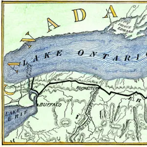
MAP OF THE ERIE CANAL. A map of the Erie Canal simplified from the Map of Routes
MAP OF THE ERIE CANAL.
A map of the Erie Canal
simplified from the Map of Routes through the Middle and Northern States, published, 1833, in Saratoga Springs, New York
Granger holds millions of images spanning more than 25,000 years of world history, from before the Stone Age to the dawn of the Space Age
Media ID 12225956
1833 Canal Erie Canal Lake Ontario New York United States
14"x18" Premium Frame
Contemporary style Premium Wooden Frame with 8"x12" Print. Complete with 2" White Mat and 1.25" thick MDF frame. Printed on 260 gsm premium paper. Glazed with shatter proof UV coated acrylic glass. Backing is paper covered backing with rubber bumpers. Supplied ready to hang with a pre-installed sawtooth/wire hanger. Care Instructions: Spot clean with a damp cloth. Securely packaged in a clear plastic bag and envelope in a reinforced cardboard shipper
FSC Real Wood Frame and Double Mounted with White Conservation Mountboard - Professionally Made and Ready to Hang
Estimated Image Size (if not cropped) is 30.4cm x 20.3cm (12" x 8")
Estimated Product Size is 45.8cm x 35.6cm (18" x 14")
These are individually made so all sizes are approximate
Artwork printed orientated as per the preview above, with landscape (horizontal) orientation to match the source image.
FEATURES IN THESE COLLECTIONS
> Granger Art on Demand
> American History
> North America
> Related Images
> North America
> United States of America
> New York
> Related Images
EDITORS COMMENTS
This print showcases a simplified map of the iconic Erie Canal, dating back to 1833. The intricate details and historical significance of this piece make it a true gem for any history enthusiast or admirer of American landmarks. The map highlights the route through the Middle and Northern States, specifically focusing on New York, where the canal was constructed. It beautifully illustrates how this engineering marvel connected Lake Ontario to the Hudson River, revolutionizing transportation in early America. Created in Saratoga Springs, New York, this map represents an important era in American history when canals played a vital role in trade and commerce. The Erie Canal not only facilitated transportation but also opened up new opportunities for settlement and economic growth along its path. As you gaze upon this print, let your imagination wander back to a time when steamboats traversed these waters and bustling towns sprung up along its banks. Appreciate the visionaries who conceived such an ambitious project and admire their determination to connect distant regions within the United States. Whether you are fascinated by cartography or simply intrigued by our nation's past, this remarkable print is sure to spark conversation and transport you back to an era filled with innovation and progress.
MADE IN THE USA
Safe Shipping with 30 Day Money Back Guarantee
FREE PERSONALISATION*
We are proud to offer a range of customisation features including Personalised Captions, Color Filters and Picture Zoom Tools
FREE COLORIZATION SERVICE
You can choose advanced AI Colorization for this picture at no extra charge!
SECURE PAYMENTS
We happily accept a wide range of payment options so you can pay for the things you need in the way that is most convenient for you
* Options may vary by product and licensing agreement. Zoomed Pictures can be adjusted in the Basket.