Premium Framed Print > Fine Art Storehouse > Map
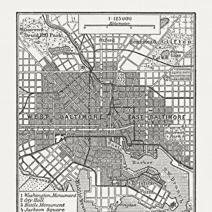
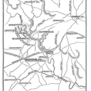
Premium Framed Print : City map of Chicago, Illinois, USA, lithograph, published in 1897


![]()
Framed Photos from Fine Art Storehouse
City map of Chicago, Illinois, USA, lithograph, published in 1897
City map of Chicago, Illinois, USA. Lithograph, published in 1897
Unleash your creativity and transform your space into a visual masterpiece!
Media ID 14756172
© This content is subject to copyright
American Culture Chicago City Map Colorful Downtown District Illinois Lake Michigan North America Shore Topographic Map Topography
14"x16" Premium Frame
Contemporary style Premium Wooden Frame with 8"x10" Print. Complete with 2" White Mat and 1.25" thick MDF frame. Printed on 260 gsm premium paper. Glazed with shatter proof UV coated acrylic glass. Backing is paper covered backing with rubber bumpers. Supplied ready to hang with a pre-installed sawtooth/wire hanger. Care Instructions: Spot clean with a damp cloth. Securely packaged in a clear plastic bag and envelope in a reinforced cardboard shipper
FSC Real Wood Frame and Double Mounted with White Conservation Mountboard - Professionally Made and Ready to Hang
Estimated Image Size (if not cropped) is 20.3cm x 25.4cm (8" x 10")
Estimated Product Size is 35.6cm x 40.6cm (14" x 16")
These are individually made so all sizes are approximate
Artwork printed orientated as per the preview above, with portrait (vertical) orientation to match the source image.
FEATURES IN THESE COLLECTIONS
> Fine Art Storehouse
> Map
> Historical Maps
> Fine Art Storehouse
> Map
> USA Maps
EDITORS COMMENTS
This vibrant lithograph print captures the essence of Chicago in 1897, showcasing the city's rich history and topography. The map, set against a clean white background, is a colorful representation of this bustling metropolis nestled along Lake Michigan's captivating coastline. The intricate details of the engraving highlight every street, district, and landmark that defined Chicago during its formative years. From the downtown district to charming neighborhoods, this map offers a glimpse into the past and serves as a testament to American culture in the late 19th century. The contrasting colors of red and white bring life to this vintage piece of art while maintaining an air of elegance. Its vertical orientation allows viewers to immerse themselves in every intricacy with ease. As we gaze upon this lithograph print today, it serves as both a historical artifact and an artistic masterpiece. It reminds us of how far Chicago has come while honoring its roots. Whether displayed in homes or offices, this iconic image evokes nostalgia for a bygone era when horse-drawn carriages traversed these streets instead of modern vehicles. With its timeless appeal and undeniable charm, this City Map of Chicago transports us back to an era where innovation was blooming amidst architectural marvels like no other city had seen before.
MADE IN THE USA
Safe Shipping with 30 Day Money Back Guarantee
FREE PERSONALISATION*
We are proud to offer a range of customisation features including Personalised Captions, Color Filters and Picture Zoom Tools
SECURE PAYMENTS
We happily accept a wide range of payment options so you can pay for the things you need in the way that is most convenient for you
* Options may vary by product and licensing agreement. Zoomed Pictures can be adjusted in the Cart.