Premium Framed Print > Arts > Contemporary art > Digital artwork > Street art
Premium Framed Print : MA Plymouth Carver Vector Road Map


![]()
Framed Photos from Fine Art Storehouse
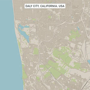
MA Plymouth Carver Vector Road Map
MA Plymouth Carver Vector Road Map. All source data is in the public domain. U.S. Census Bureau Census Tiger. Used Layers: areawater, linearwater, roads, rails, cousub, pointlm, uac10
Unleash your creativity and transform your space into a visual masterpiece!
Frank Ramspott
Media ID 20692785
© Frank Ramspott, all rights reserved
City Map Computer Graphic County Digital Composite District Geographical Border Massachusetts Plymouth Road Map Text Vector Carver Digitally Generated Image Wenham
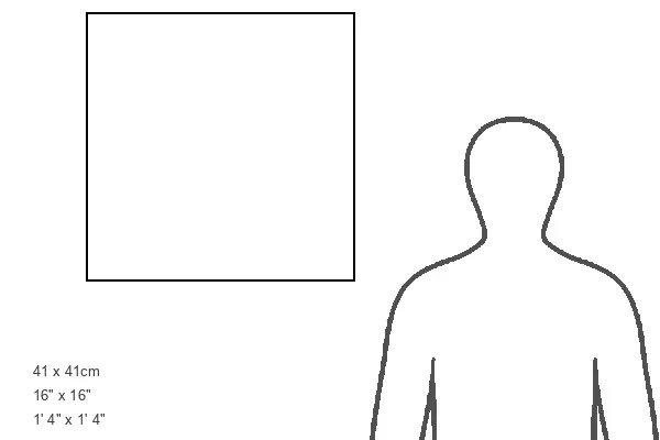
16"x16" Premium Frame
Contemporary style Premium Wooden Frame with 10"x10" Print. Complete with 2" White Mat and 1.25" thick MDF frame. Printed on 260 gsm premium paper. Glazed with shatter proof UV coated acrylic glass. Backing is paper covered backing with rubber bumpers. Supplied ready to hang with a pre-installed sawtooth/wire hanger. Care Instructions: Spot clean with a damp cloth. Securely packaged in a clear plastic bag and envelope in a reinforced cardboard shipper
FSC Real Wood Frame and Double Mounted with White Conservation Mountboard - Professionally Made and Ready to Hang
Estimated Image Size (if not cropped) is 25.4cm x 25.4cm (10" x 10")
Estimated Product Size is 40.6cm x 40.6cm (16" x 16")
These are individually made so all sizes are approximate
Artwork printed orientated as per the preview above, with landscape (horizontal) or portrait (vertical) orientation to match the source image.
FEATURES IN THESE COLLECTIONS
> Fine Art Storehouse
> Map
> Reference Maps
> Animals
> Mammals
> Cats (Wild)
> Tiger
> Animals
> Mammals
> Muridae
> Water Mouse
> Arts
> Contemporary art
> Digital artwork
> Street art
> Arts
> Landscape paintings
> Waterfall and river artworks
> River artworks
> Arts
> Portraits
> Pop art gallery
> Street art portraits
> Arts
> Street art graffiti
> Digital art
> Digital paintings
> Maps and Charts
> Related Images
> Popular Themes
> Lake District
EDITORS COMMENTS
This print showcases the MA Plymouth Carver Vector Road Map, a stunning piece of cartography art. Created by Frank Ramspott, this digitally generated image is a testament to his exceptional design skills and attention to detail. The map encompasses various layers such as areawater, linearwater, roads, rails, cousub, pointlm, and uac10. All source data used in its creation is from the public domain U. S. Census Bureau Census Tiger database. The artist has skillfully combined these elements to produce a visually striking representation of Massachusetts' Plymouth Carver region. In this color image, we witness the intricate geographical borders of cities and districts within the area. The road map provides an invaluable guide for navigation while highlighting key landmarks like rivers and lakes that shape the physical geography of this picturesque region. Notably absent from this artwork are people; instead, it focuses solely on showcasing the beauty and complexity of our surroundings through computer graphics and digital composites. This allows viewers to immerse themselves in the intricacies of city streets and textural details without any distractions. Whether you're a lover of maps or simply appreciate fine art with a touch of geographic flair, this print will undoubtedly captivate your imagination. It serves as both an aesthetically pleasing decoration for any space and a functional tool for exploring Massachusetts' Plymouth Carver region with ease.
MADE IN THE USA
Safe Shipping with 30 Day Money Back Guarantee
FREE PERSONALISATION*
We are proud to offer a range of customisation features including Personalised Captions, Color Filters and Picture Zoom Tools
SECURE PAYMENTS
We happily accept a wide range of payment options so you can pay for the things you need in the way that is most convenient for you
* Options may vary by product and licensing agreement. Zoomed Pictures can be adjusted in the Cart.