Premium Framed Print > Asia > Palestine > Maps
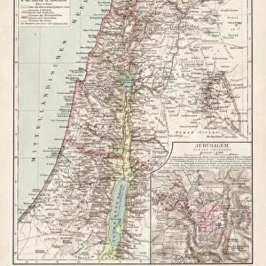
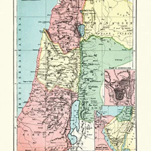
Premium Framed Print : Historical maps of Palestine and Jerusalem, lithograph, published in 1897


![]()
Framed Photos From Fine Art Storehouse
Historical maps of Palestine and Jerusalem, lithograph, published in 1897
Historical maps of Palestine with separate map of Jerusalem and surrounding area from the end of the 19th century. Lithograph, published in 1897
Unleash your creativity and transform your space into a visual masterpiece!
ZU_09
Media ID 18292205
14"x16" Premium Frame
Contemporary style Premium Wooden Frame with 8"x10" Print. Complete with 2" White Mat and 1.25" thick MDF frame. Printed on 260 gsm premium paper. Glazed with shatter proof UV coated acrylic glass. Backing is paper covered backing with rubber bumpers. Supplied ready to hang with a pre-installed sawtooth/wire hanger. Care Instructions: Spot clean with a damp cloth. Securely packaged in a clear plastic bag and envelope in a reinforced cardboard shipper
FSC Real Wood Frame and Double Mounted with White Conservation Mountboard - Professionally Made and Ready to Hang
Estimated Image Size (if not cropped) is 20.3cm x 25.4cm (8" x 10")
Estimated Product Size is 35.6cm x 40.6cm (14" x 16")
These are individually made so all sizes are approximate
Artwork printed orientated as per the preview above, with portrait (vertical) orientation to match the source image.
FEATURES IN THESE COLLECTIONS
> Asia
> Palestine
> Jerusalem
> Asia
> Palestine
> Related Images
> Maps and Charts
> Early Maps
> Maps and Charts
> Related Images
EDITORS COMMENTS
This print showcases a remarkable piece of history - historical maps of Palestine and Jerusalem, meticulously crafted in the form of lithographs and published in 1897. A true testament to the artistry and precision of cartography during the late 19th century, these maps offer a glimpse into the past, allowing us to explore the intricate details of this ancient land. The main focus lies on a separate map dedicated solely to Jerusalem and its surrounding areas. Every street, alleyway, and landmark is intricately depicted with utmost accuracy, transporting us back in time to experience the city as it was over a century ago. The lithograph technique employed adds an exquisite touch to these maps, enhancing their visual appeal while preserving their authenticity. These historical maps not only serve as valuable artifacts for collectors but also hold immense cultural significance. They provide invaluable insights into the geography and topography of Palestine at that particular period in history. As we gaze upon this mesmerizing print by ZU_09 from Fine Art Storehouse, we are reminded of how our world has evolved over time while appreciating the efforts made by those who documented it so meticulously. Whether you are an avid historian or simply captivated by beautiful works of art, this print offers both aesthetic pleasure and intellectual stimulation. It serves as a window into an era long gone yet forever preserved through these masterfully created lithographs.
MADE IN THE USA
Safe Shipping with 30 Day Money Back Guarantee
FREE PERSONALISATION*
We are proud to offer a range of customisation features including Personalised Captions, Color Filters and Picture Zoom Tools
SECURE PAYMENTS
We happily accept a wide range of payment options so you can pay for the things you need in the way that is most convenient for you
* Options may vary by product and licensing agreement. Zoomed Pictures can be adjusted in the Basket.