Premium Framed Print > Europe > Poland > Maps
Premium Framed Print : Antquie Map of Prussia


![]()
Framed Photos from Fine Art Storehouse
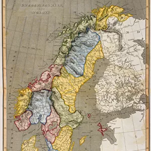
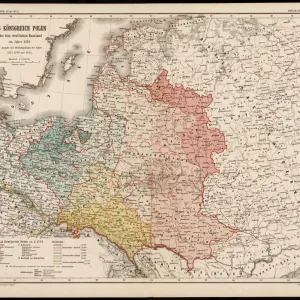
Antquie Map of Prussia
Vintage map of Prussia from 1837
Unleash your creativity and transform your space into a visual masterpiece!
duncan1890
Media ID 13597643
© duncan1890
1830 1839 Baltic Sea Bavaria Berlin Central Europe Chart Denmark Eastern Europe Equipment European Culture Geographical Locations German Culture German North Sea Region Hanover Historical Geopolitical Location Image Created 1830 1839 Image Date Manufactured Object Navigational Equipment Nordic Countries North Sea Northern Europe Objects Equipment Past Poland Pomerania Prussia Retro Revival Saxony Scandinavia Silesia Styles Traditional Culture Berlin Germany Hannover Image Created 19th Century Obsolete Retro Styled Scandinavian Peninsula Victorian Style
14"x16" Premium Frame
Contemporary style Premium Wooden Frame with 8"x10" Print. Complete with 2" White Mat and 1.25" thick MDF frame. Printed on 260 gsm premium paper. Glazed with shatter proof UV coated acrylic glass. Backing is paper covered backing with rubber bumpers. Supplied ready to hang with a pre-installed sawtooth/wire hanger. Care Instructions: Spot clean with a damp cloth. Securely packaged in a clear plastic bag and envelope in a reinforced cardboard shipper
FSC Real Wood Frame and Double Mounted with White Conservation Mountboard - Professionally Made and Ready to Hang
Estimated Image Size (if not cropped) is 25.4cm x 20.3cm (10" x 8")
Estimated Product Size is 40.6cm x 35.6cm (16" x 14")
These are individually made so all sizes are approximate
Artwork printed orientated as per the preview above, with landscape (horizontal) orientation to match the source image.
FEATURES IN THESE COLLECTIONS
> Fine Art Storehouse
> Map
> Denmark Maps
> Fine Art Storehouse
> Map
> Historical Maps
> Europe
> Denmark
> Related Images
> Europe
> Germany
> Related Images
EDITORS COMMENTS
This print showcases an exquisite "Antique Map of Prussia" dating back to 1837. A true gem from the past, this vintage map offers a glimpse into the historical geopolitical location of Prussia during the 19th century. The intricate cartography highlights various regions such as Dolnoslaskie Province, Silesia, and even extends to Nordic countries like Denmark and Scandinavia. With its Victorian-style design and retro revival aesthetic, this image transports us back in time to an era when navigational equipment relied on beautifully crafted charts like these. The detailed depiction of Baltic Sea and North Sea regions adds depth to our understanding of European culture at that time. As we explore this antique piece further, we discover capital cities like Berlin and Hanover along with other prominent German regions including Bavaria and Saxony. It is fascinating how this map captures not only the geographical locations but also reflects the traditional cultures prevalent in Eastern Europe during that period. Manufactured objects like this hold immense historical value, reminding us of a bygone era where photography was still in its infancy. This horizontal composition evokes nostalgia for a time when maps were indispensable tools for exploration and navigation. Intriguingly devoid of people, Duncan1890's photograph allows us to focus solely on the beauty and significance of this 19th-century relic. Whether you are a history enthusiast or simply appreciate fine art pieces that transport you through time, this print is sure to captivate your imagination with its rich cultural heritage
MADE IN THE USA
Safe Shipping with 30 Day Money Back Guarantee
FREE PERSONALISATION*
We are proud to offer a range of customisation features including Personalised Captions, Color Filters and Picture Zoom Tools
SECURE PAYMENTS
We happily accept a wide range of payment options so you can pay for the things you need in the way that is most convenient for you
* Options may vary by product and licensing agreement. Zoomed Pictures can be adjusted in the Cart.