Premium Framed Print > South America > Brazil > Maps
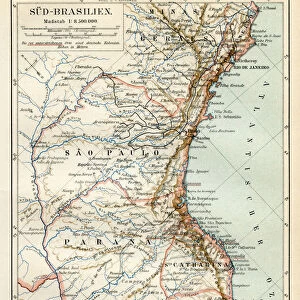
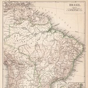
Premium Framed Print : Brazil map 1895


![]()
Framed Photos From Fine Art Storehouse
Brazil map 1895
Meyers Konversations-Lexikon. Ein Nachschlagewerk des allgemeinen Wissens, 5th edition 17 volumes Bibliographisches Institut - Leipzig 1895-1897
Unleash your creativity and transform your space into a visual masterpiece!
THEPALMER
Media ID 13611997
© This content is subject to copyright
Amazon Region Brazil Paper Parana State Sao Paulo South America World Map Amazon Parana Sao Paulo State
14"x16" Premium Frame
Contemporary style Premium Wooden Frame with 8"x10" Print. Complete with 2" White Mat and 1.25" thick MDF frame. Printed on 260 gsm premium paper. Glazed with shatter proof UV coated acrylic glass. Backing is paper covered backing with rubber bumpers. Supplied ready to hang with a pre-installed sawtooth/wire hanger. Care Instructions: Spot clean with a damp cloth. Securely packaged in a clear plastic bag and envelope in a reinforced cardboard shipper
FSC Real Wood Frame and Double Mounted with White Conservation Mountboard - Professionally Made and Ready to Hang
Estimated Image Size (if not cropped) is 20.3cm x 25.4cm (8" x 10")
Estimated Product Size is 35.6cm x 40.6cm (14" x 16")
These are individually made so all sizes are approximate
Artwork printed orientated as per the preview above, with portrait (vertical) orientation to match the source image.
FEATURES IN THESE COLLECTIONS
> Fine Art Storehouse
> The Magical World of Illustration
> Palmer Illustrated Collection
> Fine Art Storehouse
> Map
> Historical Maps
> Maps and Charts
> Related Images
> Maps and Charts
> World
> North America
> United States of America
> Maps
> South America
> Brazil
> Maps
> South America
> Brazil
> Related Images
> South America
> Brazil
> Sao Paulo
> South America
> Related Images
EDITORS COMMENTS
This print showcases a remarkable piece of history - the Brazil map from 1895. Taken from the renowned Meyers Konversations-Lexikon, an esteemed encyclopedia of general knowledge, this particular edition was published in Leipzig between 1895 and 1897. The map itself provides a fascinating glimpse into the past, depicting various regions including Amazon, Brazil, Parana, Sao Paulo, and South America. Printed on high-quality paper with exquisite attention to detail, this vertical composition captures the essence of cartography during that era. The intricate engraving and illustration techniques employed in its creation make it truly unique and reminiscent of antique maps cherished by collectors worldwide. Beyond its aesthetic appeal lies a wealth of historical significance. This old-world map not only offers insights into physical geography but also serves as a testament to the evolving boundaries and political landscapes at that time. It takes us back to an era when exploration was paramount and world maps were essential tools for understanding our planet. Whether you are an avid collector or simply appreciate fine art pieces with historical value, this Brazil map print is sure to captivate your imagination. Its presence on any wall will undoubtedly spark conversations about our ever-changing world while honoring the craftsmanship of yesteryears' cartographers.
MADE IN THE USA
Safe Shipping with 30 Day Money Back Guarantee
FREE PERSONALISATION*
We are proud to offer a range of customisation features including Personalised Captions, Color Filters and Picture Zoom Tools
SECURE PAYMENTS
We happily accept a wide range of payment options so you can pay for the things you need in the way that is most convenient for you
* Options may vary by product and licensing agreement. Zoomed Pictures can be adjusted in the Basket.