Premium Framed Print > Fine Art Storehouse > Map
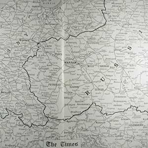
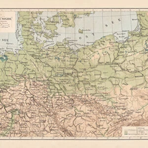
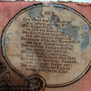
Premium Framed Print : West Russia and Baltic provinces


![]()
Framed Photos from Fine Art Storehouse
West Russia and Baltic provinces
Unleash your creativity and transform your space into a visual masterpiece!
Nastasic
Media ID 13593365
© Nikola Nastasic
1830 1839 78279 95839 Baltic Countries Baltic Sea Biological Culture Black Sea Chart Crimea Eastern Europe Equipment Geographical Locations Image Created 1830 1839 Image Date Moscow Moscow Russia Navigational Equipment Provinces Russia Russian Culture South Caucasus Styles Ukraine Image Created 19th Century Novgorod Obsolete Retro Styled Transcaucasia Victorian Style Volgograd
14"x16" Premium Frame
Contemporary style Premium Wooden Frame with 8"x10" Print. Complete with 2" White Mat and 1.25" thick MDF frame. Printed on 260 gsm premium paper. Glazed with shatter proof UV coated acrylic glass. Backing is paper covered backing with rubber bumpers. Supplied ready to hang with a pre-installed sawtooth/wire hanger. Care Instructions: Spot clean with a damp cloth. Securely packaged in a clear plastic bag and envelope in a reinforced cardboard shipper
FSC Real Wood Frame and Double Mounted with White Conservation Mountboard - Professionally Made and Ready to Hang
Estimated Image Size (if not cropped) is 20.3cm x 25.4cm (8" x 10")
Estimated Product Size is 35.6cm x 40.6cm (14" x 16")
These are individually made so all sizes are approximate
Artwork printed orientated as per the preview above, with portrait (vertical) orientation to match the source image.
FEATURES IN THESE COLLECTIONS
> Fine Art Storehouse
> The Magical World of Illustration
> Nastasic Images & Illustrations
> Fine Art Storehouse
> Map
> Historical Maps
EDITORS COMMENTS
This print takes us back in time to the 19th century, showcasing a beautifully detailed map titled "West Russia and Baltic Provinces". The retro-styled cartography, created between 1830 and 1839, exudes an antique charm that transports us to a bygone era. The image captures the rich history and cultural diversity of this region. From Novgorod to Volgograd, from Moscow to Crimea, it encompasses the vast territories of West Russia and Baltic countries in Eastern Europe. The map extends its reach towards Transcaucasia and even includes geographical locations such as the Black Sea and the Baltic Sea. With its Victorian-style illustration, this print not only serves as navigational equipment but also offers insights into Russian culture during that period. It highlights capital cities, provinces, and biological cultures within these regions. As we gaze upon this obsolete yet mesmerizing piece of artistry by Nastasic, we are reminded of how much has changed over time. It allows us to reflect on the past while appreciating our present-day advancements in technology and knowledge. Whether you are a history enthusiast or simply captivated by vintage aesthetics, this print is sure to add character to any space. Let it transport you back in time as you explore the intricate details that make up West Russia and Baltic provinces - a true testament to human curiosity about our world's diverse landscapes.
MADE IN THE USA
Safe Shipping with 30 Day Money Back Guarantee
FREE PERSONALISATION*
We are proud to offer a range of customisation features including Personalised Captions, Color Filters and Picture Zoom Tools
SECURE PAYMENTS
We happily accept a wide range of payment options so you can pay for the things you need in the way that is most convenient for you
* Options may vary by product and licensing agreement. Zoomed Pictures can be adjusted in the Cart.