Premium Framed Print > Asia > Related Images
Premium Framed Print : Russia - Central Asia and Turkey


![]()
Framed Photos from Fine Art Storehouse
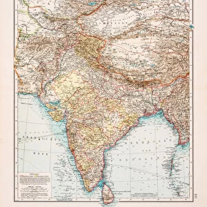
Russia - Central Asia and Turkey
Antique illustration of Russia - Central Asia and Turkey
Unleash your creativity and transform your space into a visual masterpiece!
Nastasic
Media ID 13668345
© Nikola Nastasic
1830 1839 78279 95839 Baltic Countries Baltic Sea Biological Culture Black Sea Cartographer Chart Crimea Eastern Europe Equipment Geographical Locations Image Created 1830 1839 Image Date Iran Midsection Moscow Moscow Russia Navigational Equipment Provinces Russia Russian Culture South Caucasus Styles Turkey Middle East Ukraine Image Created 19th Century Novgorod Obsolete Retro Styled Transcaucasia Victorian Style Volgograd
14"x16" Premium Frame
Contemporary style Premium Wooden Frame with 8"x10" Print. Complete with 2" White Mat and 1.25" thick MDF frame. Printed on 260 gsm premium paper. Glazed with shatter proof UV coated acrylic glass. Backing is paper covered backing with rubber bumpers. Supplied ready to hang with a pre-installed sawtooth/wire hanger. Care Instructions: Spot clean with a damp cloth. Securely packaged in a clear plastic bag and envelope in a reinforced cardboard shipper
FSC Real Wood Frame and Double Mounted with White Conservation Mountboard - Professionally Made and Ready to Hang
Estimated Image Size (if not cropped) is 25.4cm x 20.3cm (10" x 8")
Estimated Product Size is 40.6cm x 35.6cm (16" x 14")
These are individually made so all sizes are approximate
Artwork printed orientated as per the preview above, with landscape (horizontal) orientation to match the source image.
FEATURES IN THESE COLLECTIONS
> Fine Art Storehouse
> The Magical World of Illustration
> Nastasic Images & Illustrations
> Fine Art Storehouse
> Map
> Historical Maps
> Asia
> Related Images
> Asia
> Turkey
> Related Images
> Europe
> Russia
> Related Images
> Europe
> Ukraine
> Related Images
EDITORS COMMENTS
This print takes us back in time to the 19th century, showcasing an antique illustration of Russia, Central Asia, and Turkey. The retro-styled image, created between 1830 and 1839 by a skilled cartographer named Nastasic, offers a glimpse into the geographical locations and cultural diversity of this vast region. The map highlights various significant cities such as Novgorod, Volgograd (formerly known as Stalingrad), Moscow - the capital city of Russia, and Crimea. It also encompasses Baltic countries in Eastern Europe along with Turkey and parts of Iran in the Middle East. The Black Sea dominates the southern border while the Baltic Sea lies to its north. With intricate details reminiscent of Victorian style cartography, this obsolete chart showcases not only navigational equipment but also provinces and biological cultures that were prevalent during that era. As we explore this historical piece further, it becomes evident how Russian culture influenced neighboring regions like Transcaucasia. Transporting us to a time long gone by, this image evokes nostalgia for history enthusiasts who appreciate delving into past cultures and their interconnections. Its horizontal composition allows for easy examination of each region's boundaries within one frame. Whether displayed on its own or as part of a collection celebrating vintage maps or art from the 19th century, this print serves as a fascinating window into our world's rich heritage.
MADE IN THE USA
Safe Shipping with 30 Day Money Back Guarantee
FREE PERSONALISATION*
We are proud to offer a range of customisation features including Personalised Captions, Color Filters and Picture Zoom Tools
SECURE PAYMENTS
We happily accept a wide range of payment options so you can pay for the things you need in the way that is most convenient for you
* Options may vary by product and licensing agreement. Zoomed Pictures can be adjusted in the Cart.