Premium Framed Print > Fine Art Storehouse > History > Battles & Wars > Historcal Battle Maps and Plans
Premium Framed Print : Battle Field at Bull Run


![]()
Framed Photos From Fine Art Storehouse
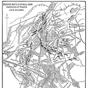
Battle Field at Bull Run
A map of the Battle field at Bull Run in Manassas, Virginia, 21 July 1861. (Photo by Archive Photos/Getty Images)
Unleash your creativity and transform your space into a visual masterpiece!
Archive Photos
Media ID 11927020
© 2010 Getty Images
14"x16" Premium Frame
Contemporary style Premium Wooden Frame with 8"x10" Print. Complete with 2" White Mat and 1.25" thick MDF frame. Printed on 260 gsm premium paper. Glazed with shatter proof UV coated acrylic glass. Backing is paper covered backing with rubber bumpers. Supplied ready to hang with a pre-installed sawtooth/wire hanger. Care Instructions: Spot clean with a damp cloth. Securely packaged in a clear plastic bag and envelope in a reinforced cardboard shipper
FSC Real Wood Frame and Double Mounted with White Conservation Mountboard - Professionally Made and Ready to Hang
Estimated Image Size (if not cropped) is 20.3cm x 25.4cm (8" x 10")
Estimated Product Size is 35.6cm x 40.6cm (14" x 16")
These are individually made so all sizes are approximate
Artwork printed orientated as per the preview above, with portrait (vertical) orientation to match the source image.
EDITORS COMMENTS
This print takes us back in time to the historic Battle of Bull Run, which unfolded on a scorching summer day in Manassas, Virginia, on July 21st, 1861. The image showcases a meticulously detailed map of the battlefield itself, providing an invaluable glimpse into one of the earliest major conflicts of the American Civil War. As we gaze upon this piece from Fine Art Storehouse's collection by Archive Photos/Getty Images, we are transported to a pivotal moment in history. The map reveals the strategic positions and movements of both Union and Confederate forces during this intense battle. It serves as a visual testament to the complexity and scale of military operations during that era. The significance of Bull Run cannot be overstated; it marked a turning point for both sides involved. This clash shattered any illusions held about swift victory and highlighted the brutal reality that lay ahead for all those embroiled in this devastating conflict. With its rich historical context and intricate details, this print allows us to delve deeper into our nation's past. It invites us to reflect upon the sacrifices made by countless soldiers who fought valiantly on these very grounds over 150 years ago. Whether you are an avid history enthusiast or simply appreciate fine art that tells compelling stories, this remarkable piece is sure to captivate your imagination and transport you back to one of America's most defining moments.
MADE IN THE USA
Safe Shipping with 30 Day Money Back Guarantee
FREE PERSONALISATION*
We are proud to offer a range of customisation features including Personalised Captions, Color Filters and Picture Zoom Tools
SECURE PAYMENTS
We happily accept a wide range of payment options so you can pay for the things you need in the way that is most convenient for you
* Options may vary by product and licensing agreement. Zoomed Pictures can be adjusted in the Basket.