Premium Framed Print > Historic > Ancient civilizations > Roman Empire > Roman art
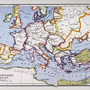
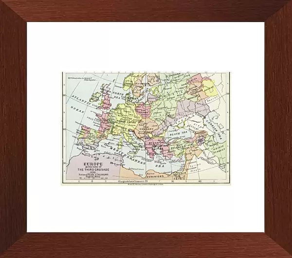
Premium Framed Print : Map of Europe at the time of the Third Crusade, 1190, from Historical Atlas


![]()
Framed Photos from Fine Art Finder
Map of Europe at the time of the Third Crusade, 1190, from Historical Atlas
KW342818 Map of Europe at the time of the Third Crusade, 1190, from Historical Atlas, published by W. & A.K. Johnston Limited, 1911 (colour litho) by English School, (20th century); Private Collection; Ken Welsh; English, out of copyright
Media ID 12861733
© www.bridgemanimages.com
Byzantine Empire C12th Crusades Holy Roman Empire Holy War Historical Map
14"x18" Premium Frame
Contemporary style Premium Wooden Frame with 8"x12" Print. Complete with 2" White Mat and 1.25" thick MDF frame. Printed on 260 gsm premium paper. Glazed with shatter proof UV coated acrylic glass. Backing is paper covered backing with rubber bumpers. Supplied ready to hang with a pre-installed sawtooth/wire hanger. Care Instructions: Spot clean with a damp cloth. Securely packaged in a clear plastic bag and envelope in a reinforced cardboard shipper
FSC Real Wood Frame and Double Mounted with White Conservation Mountboard - Professionally Made and Ready to Hang
Estimated Image Size (if not cropped) is 30.4cm x 20.3cm (12" x 8")
Estimated Product Size is 45.8cm x 35.6cm (18" x 14")
These are individually made so all sizes are approximate
Artwork printed orientated as per the preview above, with landscape (horizontal) orientation to match the source image.
FEATURES IN THESE COLLECTIONS
> Fine Art Finder
> Schools
> English School
> Arts
> Art Movements
> Medieval Art
> Arts
> Artists
> R
> Roman Roman
> Europe
> Related Images
> Historic
> Ancient civilizations
> Roman Empire
> Roman art
> Maps and Charts
> Early Maps
> Maps and Charts
> Related Images
EDITORS COMMENTS
This print showcases a historical map of Europe during the tumultuous era of the Third Crusade in 1190. Published by W. & A. K. Johnston Limited in 1911, this color lithograph offers a glimpse into the intricate cartography of the time. The map depicts a Europe deeply entrenched in medieval conflicts and religious fervor. The Holy War is at its peak, with crusaders from various European nations embarking on their journey to reclaim Jerusalem from Muslim control. The territories of the Holy Roman Empire and Byzantine Empire dominate the landscape, representing two powerful forces shaping European history. With meticulous detail, this piece transports us back to an age where borders were fluid and alliances constantly shifting. It serves as a visual testament to the complex geopolitical dynamics that defined medieval Europe. As we explore this historical gem, it becomes evident that maps are not merely tools for navigation but windows into our past. They offer insights into how societies perceived themselves and their place in the world. This print invites us to reflect on centuries-old conflicts while appreciating the artistry behind ancient cartography techniques. It reminds us that history is not confined to dusty books but can be brought vividly to life through images like these – capturing moments frozen in time for future generations to appreciate and learn from.
MADE IN THE USA
Safe Shipping with 30 Day Money Back Guarantee
FREE PERSONALISATION*
We are proud to offer a range of customisation features including Personalised Captions, Color Filters and Picture Zoom Tools
SECURE PAYMENTS
We happily accept a wide range of payment options so you can pay for the things you need in the way that is most convenient for you
* Options may vary by product and licensing agreement. Zoomed Pictures can be adjusted in the Cart.