Premium Framed Print > Europe > Italy > Sicily > Messina
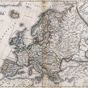
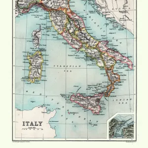
Premium Framed Print : Map of Europe and coasts of the North of Africa, 1587


![]()
Framed Photos From Fine Art Finder
Map of Europe and coasts of the North of Africa, 1587
3499620 Map of Europe and coasts of the North of Africa, 1587 by Martines, Joan (16th century); (add.info.: Map of Europe and coasts of the North of Africa. Nautical letter (Portulan) by Joan Martines. Messina, Sicily, 1587.); PHAS/UIG; Spanish, out of copyright
Media ID 22442230
© PHAS/UIG / Bridgeman Images
Coasts Joan Messina Nautical North Sicily Martines Portulan
14"x16" Premium Frame
Contemporary style Premium Wooden Frame with 8"x10" Print. Complete with 2" White Mat and 1.25" thick MDF frame. Printed on 260 gsm premium paper. Glazed with shatter proof UV coated acrylic glass. Backing is paper covered backing with rubber bumpers. Supplied ready to hang with a pre-installed sawtooth/wire hanger. Care Instructions: Spot clean with a damp cloth. Securely packaged in a clear plastic bag and envelope in a reinforced cardboard shipper
FSC Real Wood Frame and Double Mounted with White Conservation Mountboard - Professionally Made and Ready to Hang
Estimated Image Size (if not cropped) is 20.3cm x 25.4cm (8" x 10")
Estimated Product Size is 35.6cm x 40.6cm (14" x 16")
These are individually made so all sizes are approximate
Artwork printed orientated as per the preview above, with portrait (vertical) orientation to match the source image.
FEATURES IN THESE COLLECTIONS
> Fine Art Finder
> Artists
> Joan Martines
> Fine Art Finder
> Artists
> Spanish School (after)
> Europe
> Italy
> Sicily
> Messina
> Europe
> Italy
> Sicily
> Related Images
> Maps and Charts
> Related Images
> Maps and Charts
> Spain
EDITORS COMMENTS
This print showcases a remarkable piece of cartographic history - the "Map of Europe and coasts of the North of Africa, 1587" by Joan Martines. Created in Messina, Sicily during the 16th century, this nautical letter (Portulan) offers a fascinating glimpse into the geographical knowledge and navigational techniques of that era. The intricate details depicted on this map transport us back to a time when exploration and discovery were at their peak. With its meticulously drawn coastlines, cities, and landmarks, it serves as an invaluable record of how Europeans perceived their world centuries ago. The inclusion of North African coasts adds another layer to its significance, highlighting the interconnectedness between these regions during that period. As we study this ancient artifact through modern eyes, we can't help but marvel at Martines' skillful craftsmanship and attention to detail. Every stroke seems purposeful; every contour carefully considered. It is evident that this map was not only intended for practical use but also served as a work of art in its own right. Thanks to Bridgeman Images' preservation efforts, we are fortunate enough to have access to such historical treasures like this one. This print allows us to appreciate Martines' masterpiece from afar while reminding us of our shared human curiosity for exploration and understanding.
MADE IN THE USA
Safe Shipping with 30 Day Money Back Guarantee
FREE PERSONALISATION*
We are proud to offer a range of customisation features including Personalised Captions, Color Filters and Picture Zoom Tools
SECURE PAYMENTS
We happily accept a wide range of payment options so you can pay for the things you need in the way that is most convenient for you
* Options may vary by product and licensing agreement. Zoomed Pictures can be adjusted in the Basket.