Premium Framed Print > Fine Art Finder > Artists > Sebastien Le Prestre de Vauban
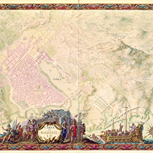
Premium Framed Print : Ms. 987, fol. 24 Plan of Le Havre, from the Atlas Louis XIV, 1683-88 (gouache


Please select a smaller print size for this image
![]()
Framed Photos from Fine Art Finder
Ms. 987, fol. 24 Plan of Le Havre, from the Atlas Louis XIV, 1683-88 (gouache
XIR232105 Ms. 987, fol.24 Plan of Le Havre, from the Atlas Louis XIV, 1683-88 (gouache on paper) by Vauban, Sebastien Le Prestre de (1633-1707); Min. Defense - Service Historique de l Armee de Terre, France; French, out of copyright
Media ID 12766916
© www.bridgemanimages.com
Bastion Fortified City Star Defence System
14"x16" Premium Frame
Contemporary style Premium Wooden Frame with 8"x10" Print. Complete with 2" White Mat and 1.25" thick MDF frame. Printed on 260 gsm premium paper. Glazed with shatter proof UV coated acrylic glass. Backing is paper covered backing with rubber bumpers. Supplied ready to hang with a pre-installed sawtooth/wire hanger. Care Instructions: Spot clean with a damp cloth. Securely packaged in a clear plastic bag and envelope in a reinforced cardboard shipper
FSC Real Wood Frame and Double Mounted with White Conservation Mountboard - Professionally Made and Ready to Hang
Estimated Image Size (if not cropped) is 25.4cm x 20.3cm (10" x 8")
Estimated Product Size is 40.6cm x 35.6cm (16" x 14")
These are individually made so all sizes are approximate
Artwork printed orientated as per the preview above, with landscape (horizontal) orientation to match the source image.
EDITORS COMMENTS
This print showcases the intricate "Plan of Le Havre" from the renowned Atlas Louis XIV, created between 1683-88 by Sebastien Le Prestre de Vauban. The artist's exceptional talent is evident in this gouache on paper masterpiece, which offers a detailed depiction of the fortified city. Le Havre, a town located in France, is brought to life through this artwork. Every bastion and fortress within its walls are meticulously illustrated, showcasing the genius behind Vauban's star defense system. This plan serves as a testament to his expertise in fortification design and military strategy during the reign of King Louis XIV. The historical significance of this piece cannot be overstated. Preserved by Min. Defense - Service Historique de l'Armee de Terre in France, it provides us with an invaluable glimpse into the past. As we admire this print today, we can appreciate both its artistic beauty and its role as a vital historical document. With its vibrant colors and intricate details, this image transports us back to an era when fortified cities played a crucial role in protecting nations from external threats. It reminds us of the rich history that lies within every corner of our world.
MADE IN THE USA
Safe Shipping with 30 Day Money Back Guarantee
FREE PERSONALISATION*
We are proud to offer a range of customisation features including Personalised Captions, Color Filters and Picture Zoom Tools
SECURE PAYMENTS
We happily accept a wide range of payment options so you can pay for the things you need in the way that is most convenient for you
* Options may vary by product and licensing agreement. Zoomed Pictures can be adjusted in the Cart.