Premium Framed Print > Europe > Italy > Related Images
Premium Framed Print : Ms Lat 463 fol. 81v-82r Map of Gaul, Belgium, Lyon and Aquitaine (vellum)
")

")


Please select a smaller print size for this image
![]()
Framed Photos From Fine Art Finder
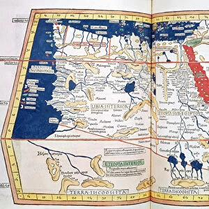
Ms Lat 463 fol. 81v-82r Map of Gaul, Belgium, Lyon and Aquitaine (vellum)
XAL247281 Ms Lat 463 fol.81v-82r Map of Gaul, Belgium, Lyon and Aquitaine (vellum) by Ptolemy (Claudius Ptolemaeus of Alexandria)(c.90-168)(after); Biblioteca Estense, Modena, Italy; Greek, out of copyright
Media ID 12764433
© www.bridgemanart.com
Belgique Gallia Gaule Belgica Lyonnaise
14"x16" Premium Frame
Contemporary style Premium Wooden Frame with 8"x10" Print. Complete with 2" White Mat and 1.25" thick MDF frame. Printed on 260 gsm premium paper. Glazed with shatter proof UV coated acrylic glass. Backing is paper covered backing with rubber bumpers. Supplied ready to hang with a pre-installed sawtooth/wire hanger. Care Instructions: Spot clean with a damp cloth. Securely packaged in a clear plastic bag and envelope in a reinforced cardboard shipper
FSC Real Wood Frame and Double Mounted with White Conservation Mountboard - Professionally Made and Ready to Hang
Estimated Image Size (if not cropped) is 25.4cm x 20.3cm (10" x 8")
Estimated Product Size is 40.6cm x 35.6cm (16" x 14")
These are individually made so all sizes are approximate
Artwork printed orientated as per the preview above, with landscape (horizontal) orientation to match the source image.
FEATURES IN THESE COLLECTIONS
> Fine Art Finder
> Artists
> P
> Ptolemy (c.90-168)(after) Ptolemy
> Fine Art Finder
> Artists
> Ptolemy (c.90-168)(after)
> Europe
> Italy
> Related Images
EDITORS COMMENTS
This print showcases the exquisite "Ms Lat 463 fol. 81v-82r Map of Gaul, Belgium, Lyon and Aquitaine" by the renowned ancient geographer Ptolemy. Crafted on vellum, this remarkable piece of art is housed in the Biblioteca Estense in Modena, Italy. The map takes us back to a time when cartography was still in its infancy, offering a glimpse into the world as it was perceived during Ptolemy's era. With intricate details and delicate craftsmanship, this masterpiece depicts Gaul, Belgium, Lyon and Aquitaine with astonishing accuracy. As we explore this ancient treasure further, we are transported to an age where empires reigned supreme. The Roman Empire stretches across these lands depicted on the map - Gallia (France), Belgica (Belgium), Lugdunensis (Lyon) and Aquitannia (Aquitaine). It serves as a testament to Ptolemy's meticulous research and his contribution to our understanding of geography. This print allows us to appreciate not only the historical significance but also the artistic beauty that lies within this extraordinary work. The fine lines etched onto vellum create a visual feast for our eyes while reminding us of humanity's ceaseless quest for knowledge and exploration. Let this stunning image transport you back in time as you marvel at Ptolemy's genius and immerse yourself in an era long gone yet forever preserved through art.
MADE IN THE USA
Safe Shipping with 30 Day Money Back Guarantee
FREE PERSONALISATION*
We are proud to offer a range of customisation features including Personalised Captions, Color Filters and Picture Zoom Tools
SECURE PAYMENTS
We happily accept a wide range of payment options so you can pay for the things you need in the way that is most convenient for you
* Options may vary by product and licensing agreement. Zoomed Pictures can be adjusted in the Basket.