Premium Framed Print > Arts > Artists > F > William Faden
Premium Framed Print : Map of Ireland, 1798


![]()
Framed Photos From Fine Art Finder
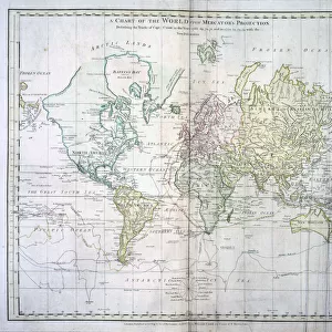
Map of Ireland, 1798
7261222 Map of Ireland, 1798 by Faden, William (1750-1836); Private Collection; (add.info.: Ireland Divided into Provinces and Counties. 1798 map by cartographer William Faden, engraved by William Palmer. Faden was the royal geographer to King George III. This map comes from his Atlas minimus universalis which was designed mainly for use in schools.); Photo © Ken Welsh. All rights reserved 2022
Media ID 25300941
© Ken Welsh. All rights reserved 2022 / Bridgeman Images
Ireland Irish North Of Ireland C European Economic Community C European Union
14"x16" Premium Frame
Contemporary style Premium Wooden Frame with 8"x10" Print. Complete with 2" White Mat and 1.25" thick MDF frame. Printed on 260 gsm premium paper. Glazed with shatter proof UV coated acrylic glass. Backing is paper covered backing with rubber bumpers. Supplied ready to hang with a pre-installed sawtooth/wire hanger. Care Instructions: Spot clean with a damp cloth. Securely packaged in a clear plastic bag and envelope in a reinforced cardboard shipper
FSC Real Wood Frame and Double Mounted with White Conservation Mountboard - Professionally Made and Ready to Hang
Estimated Image Size (if not cropped) is 20.3cm x 25.4cm (8" x 10")
Estimated Product Size is 35.6cm x 40.6cm (14" x 16")
These are individually made so all sizes are approximate
Artwork printed orientated as per the preview above, with portrait (vertical) orientation to match the source image.
FEATURES IN THESE COLLECTIONS
> Animals
> Mammals
> Sciuridae
> Minimus
> Arts
> Artists
> F
> William Faden
> Arts
> Artists
> I
> Irish School Irish School
> Arts
> Artists
> I
> William Ireland
> Europe
> Republic of Ireland
> Maps
> Maps and Charts
> Early Maps
> Maps and Charts
> Related Images
EDITORS COMMENTS
This print showcases a remarkable piece of history - the "Map of Ireland, 1798" by William Faden. Created during the 18th century, this artful engraving depicts Ireland divided into provinces and counties. The vibrant colors bring life to the intricate details of this map, allowing viewers to immerse themselves in the geography and boundaries of that era. William Faden, renowned as the royal geographer to King George III, crafted this map with precision and expertise. Engraved by William Palmer, it is evident that great care was taken in its creation. Originally intended for educational purposes in schools, this map from Faden's Atlas minimus universalis holds immense historical significance. The print captures every nuance and subtlety of Faden's work, thanks to Ken Welsh's exceptional photography skills. It allows us to appreciate not only the artistic beauty but also the cultural importance of this piece. As we gaze upon it, we are transported back in time to witness Ireland as it existed over two centuries ago. From an academic perspective or simply as an admirer of fine art, one cannot help but be captivated by this stunning representation of Irish cartography. It serves as a testament to both Faden's mastery as a cartographer and Welsh's talent behind the lens. With all rights reserved for Ken Welsh’s photograph through Fine Art Finder platform in 2022; let us cherish and celebrate this extraordinary glimpse into Ireland's past through such magnificent works of art like
MADE IN THE USA
Safe Shipping with 30 Day Money Back Guarantee
FREE PERSONALISATION*
We are proud to offer a range of customisation features including Personalised Captions, Color Filters and Picture Zoom Tools
SECURE PAYMENTS
We happily accept a wide range of payment options so you can pay for the things you need in the way that is most convenient for you
* Options may vary by product and licensing agreement. Zoomed Pictures can be adjusted in the Basket.