Premium Framed Print > Europe > France > Maps
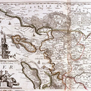
Premium Framed Print : Map of the Northeast of Ile de France, 1698 (Engraving, 1717)
")
")


![]()
Framed Photos From Fine Art Finder
Map of the Northeast of Ile de France, 1698 (Engraving, 1717)
LRI4711594 Map of the Northeast of Ile de France, 1698 (Engraving, 1717) by Nolin, Jean-Baptiste (c.1657-1708); Private Collection; (add.info.: Map of the regions of the north east of the island of France: the country Valois, the Count and Presidial of Meaux, 1698 - Engraving from the atlas le theatre du monde, 1717, by Jean Baptiste Nolin (1657-1708) - Map of the Northeast of Ile de France, 1698 - From " Le Theatre du Monde" 1717 by Jean-Baptiste Nolin); Luisa Ricciarini; French, out of copyright
Media ID 23329508
© Luisa Ricciarini / Bridgeman Images
Atlas Book Island Of France Geographical Map
14"x16" Premium Frame
Contemporary style Premium Wooden Frame with 8"x10" Print. Complete with 2" White Mat and 1.25" thick MDF frame. Printed on 260 gsm premium paper. Glazed with shatter proof UV coated acrylic glass. Backing is paper covered backing with rubber bumpers. Supplied ready to hang with a pre-installed sawtooth/wire hanger. Care Instructions: Spot clean with a damp cloth. Securely packaged in a clear plastic bag and envelope in a reinforced cardboard shipper
FSC Real Wood Frame and Double Mounted with White Conservation Mountboard - Professionally Made and Ready to Hang
Estimated Image Size (if not cropped) is 25.4cm x 20.3cm (10" x 8")
Estimated Product Size is 40.6cm x 35.6cm (16" x 14")
These are individually made so all sizes are approximate
Artwork printed orientated as per the preview above, with landscape (horizontal) orientation to match the source image.
FEATURES IN THESE COLLECTIONS
> Fine Art Finder
> Artists
> Jean-Baptiste Nolin
> Maps and Charts
> Related Images
> Popular Themes
> North Island
EDITORS COMMENTS
This print showcases a historical treasure, the "Map of the Northeast of Ile de France" from 1698. Created by Jean-Baptiste Nolin, a renowned French cartographer, this engraving offers an intricate depiction of the regions in the northeast part of the island. The map encompasses various areas such as Valois, Count and Presidial of Meaux. Originally published in 1717 as part of Nolin's atlas "Le Theatre du Monde" this piece is a testament to his exceptional skill and attention to detail. It provides us with invaluable insights into the geographical landscape and political divisions during that period. The delicate engravings on this map are truly mesmerizing; they showcase rivers winding through lush landscapes, towns marked with tiny symbols, and borders meticulously outlined. Each element tells its own story about life in 17th-century France. Luisa Ricciarini has beautifully captured this historic artwork through her lens, preserving it for generations to come. This photograph allows us to appreciate not only Nolin's artistry but also Ricciarini's talent in capturing every minute detail. As we gaze upon this image, we are transported back in time – imagining ourselves exploring these ancient lands or tracing our fingers along each contour line. It serves as a reminder that maps hold more than just geographic information; they carry stories from our past and offer glimpses into worlds long gone.
MADE IN THE USA
Safe Shipping with 30 Day Money Back Guarantee
FREE PERSONALISATION*
We are proud to offer a range of customisation features including Personalised Captions, Color Filters and Picture Zoom Tools
SECURE PAYMENTS
We happily accept a wide range of payment options so you can pay for the things you need in the way that is most convenient for you
* Options may vary by product and licensing agreement. Zoomed Pictures can be adjusted in the Basket.