Premium Framed Print > Arts > Artists > B > Joan Blaeu
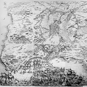
Premium Framed Print : Tabula Magellanica : map of strait of Magellan, 1662 (engraving)
")

")


![]()
Framed Photos From Fine Art Finder
Tabula Magellanica : map of strait of Magellan, 1662 (engraving)
1797090 Tabula Magellanica : map of strait of Magellan, 1662 (engraving) by Blaeu, Joan (1596-1673); (add.info.: Tabula Magellanica : map of strait of Magellan, engraving from Atlas Maior sive Cosmographia Blaviana by Joan Blaeu, 1662); Photo © CCI
Media ID 31949510
© CCI / Bridgeman Images
17e Xviie Siecle 17th Century Amerique Du Sud South America Explorateur Exploration Explorer
14"x16" Premium Frame
Contemporary style Premium Wooden Frame with 8"x10" Print. Complete with 2" White Mat and 1.25" thick MDF frame. Printed on 260 gsm premium paper. Glazed with shatter proof UV coated acrylic glass. Backing is paper covered backing with rubber bumpers. Supplied ready to hang with a pre-installed sawtooth/wire hanger. Care Instructions: Spot clean with a damp cloth. Securely packaged in a clear plastic bag and envelope in a reinforced cardboard shipper
FSC Real Wood Frame and Double Mounted with White Conservation Mountboard - Professionally Made and Ready to Hang
Estimated Image Size (if not cropped) is 25.4cm x 20.3cm (10" x 8")
Estimated Product Size is 40.6cm x 35.6cm (16" x 14")
These are individually made so all sizes are approximate
Artwork printed orientated as per the preview above, with landscape (horizontal) orientation to match the source image.
FEATURES IN THESE COLLECTIONS
> Fine Art Finder
> Artists
> Jacques Callot
> Fine Art Finder
> Artists
> Joan Blaeu
> Arts
> Artists
> B
> Joan Blaeu
> Maps and Charts
> Early Maps
> Maps and Charts
> Related Images
> South America
> Related Images
EDITORS COMMENTS
This print showcases the intricate details of "Tabula Magellanica: map of strait of Magellan, 1662". Created by Joan Blaeu, a renowned cartographer from the 17th century, this engraving is a true testament to his mastery in capturing geographical accuracy and artistic finesse. The vibrant colors bring life to this historic piece, transporting us back to an era when exploration was at its peak. The map depicts the Strait of Magellan, a treacherous passage that connects the Atlantic and Pacific Oceans. It serves as a visual guide for explorers venturing into uncharted territories during that time. As we gaze upon this print, we are reminded of the bravery and curiosity that drove these early explorers. Their journeys across South America were filled with danger and uncertainty, yet they persevered in their quest for discovery. The attention to detail in this engraving is truly remarkable. Every contour of landmasses and every ripple in the ocean's surface has been meticulously etched onto paper. This level of precision not only aids navigation but also adds an aesthetic appeal to the artwork itself. "Tabula Magellanica: map of strait of Magellan" stands as both a historical artifact and a work of art. It allows us to appreciate the beauty found within scientific documentation while offering insight into our collective human desire for exploration and understanding.
MADE IN THE USA
Safe Shipping with 30 Day Money Back Guarantee
FREE PERSONALISATION*
We are proud to offer a range of customisation features including Personalised Captions, Color Filters and Picture Zoom Tools
SECURE PAYMENTS
We happily accept a wide range of payment options so you can pay for the things you need in the way that is most convenient for you
* Options may vary by product and licensing agreement. Zoomed Pictures can be adjusted in the Basket.