Premium Framed Print > Arts > Artists > I > Italian School Italian School
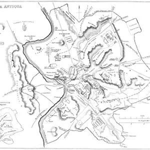
Premium Framed Print : Map of the walls and seven hills of ancient Rome (litho)
")
")


![]()
Framed Photos From Fine Art Finder
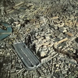
Map of the walls and seven hills of ancient Rome (litho)
7200985 Map of the walls and seven hills of ancient Rome (litho) by English School, (19th century); Private Collection; (add.info.: Map of the walls and seven hills of Rome during the Roman Empire. Illustration from Res Romanae, by Edward P Coleridge (George Bell and Sons, London, 1896).); © Look and Learn
Media ID 24728928
© Look and Learn / Bridgeman Images
City Map City Plan General Map Hills Hilly Latium Seven Hills Street Plan Urban Districts Walls Antic Rome Antiquit
14"x16" Premium Frame
Contemporary style Premium Wooden Frame with 8"x10" Print. Complete with 2" White Mat and 1.25" thick MDF frame. Printed on 260 gsm premium paper. Glazed with shatter proof UV coated acrylic glass. Backing is paper covered backing with rubber bumpers. Supplied ready to hang with a pre-installed sawtooth/wire hanger. Care Instructions: Spot clean with a damp cloth. Securely packaged in a clear plastic bag and envelope in a reinforced cardboard shipper
FSC Real Wood Frame and Double Mounted with White Conservation Mountboard - Professionally Made and Ready to Hang
Estimated Image Size (if not cropped) is 25.4cm x 20.3cm (10" x 8")
Estimated Product Size is 40.6cm x 35.6cm (16" x 14")
These are individually made so all sizes are approximate
Artwork printed orientated as per the preview above, with landscape (horizontal) orientation to match the source image.
FEATURES IN THESE COLLECTIONS
> Fine Art Finder
> Artists
> English School
> Arts
> Artists
> I
> Italian School Italian School
> Arts
> Artists
> R
> Roman Roman
> Arts
> Artists
> W
> George White
> Arts
> Portraits
> Pop art gallery
> Street art portraits
> Europe
> Italy
> Lazio
> Rome
> Historic
> Ancient civilizations
> Roman Empire
> Ancient roman cities
> Historic
> Ancient civilizations
> Roman Empire
> Ancient Rome
> Historic
> Ancient civilizations
> Roman Empire
> Roman art
EDITORS COMMENTS
This lithograph print showcases a detailed map of the walls and seven hills of ancient Rome, offering a glimpse into the grandeur and complexity of the Roman Empire. Created by an English School artist in the 19th century, this artwork is part of a private collection. The map, originally featured in Edward P Coleridge's Res Romanae (1896), provides an invaluable visual representation of Rome during its imperial era. It highlights the city's topography, with its hilly terrain and fortified walls that once protected this historic metropolis. Every street plan and urban district is meticulously illustrated, allowing viewers to immerse themselves in ancient Roman history. The black-and-white lithograph adds a touch of antiquity to this piece, enhancing its historical allure. As you explore this map, you can't help but marvel at how it encapsulates centuries worth of stories within its intricate details. From bustling streets to majestic landmarks like the Colosseum or Pantheon, every corner seems alive with remnants from one of history's greatest civilizations. This artwork serves as both an educational tool for historians and a testament to human ingenuity and architectural prowess. It reminds us that even after thousands of years have passed since ancient Rome flourished, its legacy continues to captivate our imagination.
MADE IN THE USA
Safe Shipping with 30 Day Money Back Guarantee
FREE PERSONALISATION*
We are proud to offer a range of customisation features including Personalised Captions, Color Filters and Picture Zoom Tools
SECURE PAYMENTS
We happily accept a wide range of payment options so you can pay for the things you need in the way that is most convenient for you
* Options may vary by product and licensing agreement. Zoomed Pictures can be adjusted in the Basket.