Premium Framed Print > Maps and Charts > Related Images
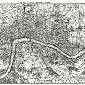
Premium Framed Print : Map of the London Postal Districts (engraving)
")
")


![]()
Framed Photos From Fine Art Finder
Map of the London Postal Districts (engraving)
1587268 Map of the London Postal Districts (engraving) by English School, (19th century); Private Collection; (add.info.: Map of the London Postal Districts. Illustration for The Illustrated London News, 17 January 1857.
English School (19th Century)); Look and Learn / Illustrated Papers Collection
Media ID 22550752
© Look and Learn / Illustrated Papers Collection / Bridgeman Images
16"x16" Premium Frame
Contemporary style Premium Wooden Frame with 10"x10" Print. Complete with 2" White Mat and 1.25" thick MDF frame. Printed on 260 gsm premium paper. Glazed with shatter proof UV coated acrylic glass. Backing is paper covered backing with rubber bumpers. Supplied ready to hang with a pre-installed sawtooth/wire hanger. Care Instructions: Spot clean with a damp cloth. Securely packaged in a clear plastic bag and envelope in a reinforced cardboard shipper
FSC Real Wood Frame and Double Mounted with White Conservation Mountboard - Professionally Made and Ready to Hang
Estimated Image Size (if not cropped) is 25.4cm x 25.4cm (10" x 10")
Estimated Product Size is 40.6cm x 40.6cm (16" x 16")
These are individually made so all sizes are approximate
Artwork printed orientated as per the preview above, with landscape (horizontal) or portrait (vertical) orientation to match the source image.
EDITORS COMMENTS
This engraving, titled "Map of the London Postal Districts" takes us back to the bustling streets of 19th-century London. Created by an English School artist and featured in The Illustrated London News on January 17,1857, this print offers a fascinating glimpse into the city's postal network during that era. The intricate details showcased in this map are truly remarkable. Each district is meticulously outlined, revealing the extensive reach of London's postal system at the time. From vibrant central areas to more remote corners, this engraving illustrates how letters and parcels were transported across the vast metropolis. As we study this historical artifact, it becomes evident that communication was a vital aspect of daily life even then. This map serves as a reminder of how crucial efficient mail delivery was for businesses and individuals alike. It also highlights the immense growth and development occurring within London during this period. Through its fine craftsmanship and attention to detail, Bridgeman Images has beautifully preserved this piece of history for us to admire today. Whether you're a lover of maps or simply intrigued by old-world charm, "Map of the London Postal Districts" is sure to transport you back in time and ignite your curiosity about life in Victorian-era England.
MADE IN THE USA
Safe Shipping with 30 Day Money Back Guarantee
FREE PERSONALISATION*
We are proud to offer a range of customisation features including Personalised Captions, Color Filters and Picture Zoom Tools
SECURE PAYMENTS
We happily accept a wide range of payment options so you can pay for the things you need in the way that is most convenient for you
* Options may vary by product and licensing agreement. Zoomed Pictures can be adjusted in the Basket.