Premium Framed Print > Fine Art Finder > Artists > Charles Marie Rigobert Bonne
Premium Framed Print : Arabia, the Persian Gulf and the Red Sea, with Egypt, Nubia and Abyssinia, from Atlas


Please select a smaller print size for this image
![]()
Framed Photos from Fine Art Finder
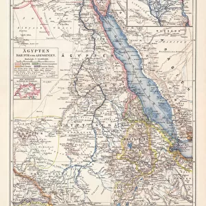
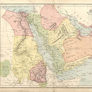
Arabia, the Persian Gulf and the Red Sea, with Egypt, Nubia and Abyssinia, from Atlas
KW205852 Arabia, the Persian Gulf and the Red Sea, with Egypt, Nubia and Abyssinia, from Atlas de Toutes les Parties Connues du Globe Terrestre by Guillaume Raynal (1713-96) published Geneva, 1780 (coloured engraving) by Bonne, Charles Marie Rigobert (1727-95); Private Collection; Ken Welsh; French, out of copyright
Media ID 12755445
© www.bridgemanimages.com
Eritrea Ethiopia Oman Yemen Saudi Sudan
14"x18" Premium Frame
Contemporary style Premium Wooden Frame with 8"x12" Print. Complete with 2" White Mat and 1.25" thick MDF frame. Printed on 260 gsm premium paper. Glazed with shatter proof UV coated acrylic glass. Backing is paper covered backing with rubber bumpers. Supplied ready to hang with a pre-installed sawtooth/wire hanger. Care Instructions: Spot clean with a damp cloth. Securely packaged in a clear plastic bag and envelope in a reinforced cardboard shipper
FSC Real Wood Frame and Double Mounted with White Conservation Mountboard - Professionally Made and Ready to Hang
Estimated Image Size (if not cropped) is 30.4cm x 20.3cm (12" x 8")
Estimated Product Size is 45.8cm x 35.6cm (18" x 14")
These are individually made so all sizes are approximate
Artwork printed orientated as per the preview above, with landscape (horizontal) orientation to match the source image.
EDITORS COMMENTS
This print showcases the intricate beauty of Arabia, the Persian Gulf, and the Red Sea, along with Egypt, Nubia, and Abyssinia. A masterpiece from the renowned Atlas de Toutes les Parties Connues du Globe Terrestre by Guillaume Raynal, this colored engraving takes us on a visual journey through these enchanting regions. Published in Geneva in 1780 by Charles Marie Rigobert Bonne, this historical map offers a glimpse into the past as it captures an era long gone. The delicate details and vibrant hues bring to life the diverse landscapes and rich cultural heritage of Saudi Arabia, Sudan, Ethiopia, Yemen Oman Eritrea, and Somali Republic. As we gaze upon this remarkable artwork preserved in a private collection under Ken Welsh's care, we are transported back to a time when exploration was at its peak. This print not only serves as a testament to human curiosity but also highlights the importance of cartography in understanding our world. Let your imagination wander as you trace ancient trade routes across vast deserts or sail through treacherous waters teeming with marine life. Allow yourself to be captivated by the sheer magnitude of these lands that have witnessed countless civilizations rise and fall throughout history. Whether you appreciate artistry or harbor an insatiable thirst for knowledge about our planet's past inhabitants and their interconnectedness across borders - this extraordinary print is sure to leave you awe-inspired.
MADE IN THE USA
Safe Shipping with 30 Day Money Back Guarantee
FREE PERSONALISATION*
We are proud to offer a range of customisation features including Personalised Captions, Color Filters and Picture Zoom Tools
SECURE PAYMENTS
We happily accept a wide range of payment options so you can pay for the things you need in the way that is most convenient for you
* Options may vary by product and licensing agreement. Zoomed Pictures can be adjusted in the Cart.