Premium Framed Print > Africa > Related Images
Premium Framed Print : The Continent of Africa, from an Atlas of the World in 33 Maps, Venice, 1st September 1553


Please select a smaller print size for this image
![]()
Framed Photos from Fine Art Finder
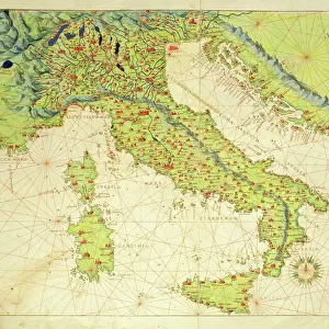
The Continent of Africa, from an Atlas of the World in 33 Maps, Venice, 1st September 1553
XOT330946 The Continent of Africa, from an Atlas of the World in 33 Maps, Venice, 1st September 1553 (ink on vellum) (see also 330947) by Agnese, Battista (1514-64); Museo Correr, Venice, Italy; Italian, out of copyright
Media ID 12852645
© www.bridgemanart.com
Atlantic Ocean Equator Indian Ocean Lakes Madagascar Mapping Red Sea Tropic Of Cancer Tropic Of Capricorn
14"x16" Premium Frame
Contemporary style Premium Wooden Frame with 8"x10" Print. Complete with 2" White Mat and 1.25" thick MDF frame. Printed on 260 gsm premium paper. Glazed with shatter proof UV coated acrylic glass. Backing is paper covered backing with rubber bumpers. Supplied ready to hang with a pre-installed sawtooth/wire hanger. Care Instructions: Spot clean with a damp cloth. Securely packaged in a clear plastic bag and envelope in a reinforced cardboard shipper
FSC Real Wood Frame and Double Mounted with White Conservation Mountboard - Professionally Made and Ready to Hang
Estimated Image Size (if not cropped) is 25.4cm x 20.3cm (10" x 8")
Estimated Product Size is 40.6cm x 35.6cm (16" x 14")
These are individually made so all sizes are approximate
Artwork printed orientated as per the preview above, with landscape (horizontal) orientation to match the source image.
FEATURES IN THESE COLLECTIONS
> Fine Art Finder
> Artists
> Battista Agnese
> Africa
> Related Images
> Europe
> Italy
> Related Images
EDITORS COMMENTS
This print showcases "The Continent of Africa" from an ancient atlas, created by the talented cartographer Battista Agnese in Venice on 1st September 1553. The intricate details and exquisite craftsmanship of this ink on vellum masterpiece are truly awe-inspiring. As we delve into the map, our eyes are immediately drawn to the vastness and diversity of Africa's landscape. From the majestic Atlas Mountains in the north to the lush rainforests and expansive savannahs further south, every contour is meticulously depicted. Rivers meander through its terrain, nourishing fertile lands along their course. The map also highlights significant geographical features such as Madagascar, situated off Africa's eastern coast like a precious gem in the Indian Ocean. The Red Sea connects Africa with Asia, while both the Atlantic Ocean and Indian Ocean embrace its shores. Notably marked are important lines of latitude including the Equator, Tropic of Cancer, and Tropic of Capricorn – defining climatic zones that shape Africa's unique ecosystems. This visual representation allows us to appreciate how these factors influence everything from wildlife distribution to agricultural practices across different regions. "The Continent of Africa" serves as a testament to Agnese's mastery in capturing not only geographic accuracy but also evoking curiosity about distant lands during a time when exploration was still unfolding. It invites us to embark on a journey through history and geography while marveling at this remarkable work preserved within Museo Correr in Venice today.
MADE IN THE USA
Safe Shipping with 30 Day Money Back Guarantee
FREE PERSONALISATION*
We are proud to offer a range of customisation features including Personalised Captions, Color Filters and Picture Zoom Tools
SECURE PAYMENTS
We happily accept a wide range of payment options so you can pay for the things you need in the way that is most convenient for you
* Options may vary by product and licensing agreement. Zoomed Pictures can be adjusted in the Cart.