Premium Framed Print > North America > United States of America > New York > New York > Maps
Premium Framed Print : A plan of New York Island, with part of Long Island, Staten Island & East New Jersey


![]()
Framed Photos From Fine Art Finder
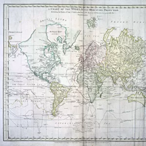
A plan of New York Island, with part of Long Island, Staten Island & East New Jersey
1079221 A plan of New York Island, with part of Long Island, Staten Island & East New Jersey, with a particular description of the engagement on the woody heights of Long Island between Flatbush and Brooklyn on the 27th of August 1776, 1776 (black ink and colour wash on paper) by Faden, William (1750-1836); 17x56 cm; Collection of the New-York Historical Society, USA; (add.info.: A plan of New York Island, with part of Long Island, Staten Island & East New Jersey, with a particular description of the engagement on the woody heights of Long Island between Flatbush and Brooklyn on the 27th of August 1776, 17 x 56 cm.); eNew York Historical Society; British, out of copyright
Media ID 22621838
© New York Historical Society / Bridgeman Images
Brooklyn Long Island Manhattan New Jersey Staten Island Surveys
14"x16" Premium Frame
Contemporary style Premium Wooden Frame with 8"x10" Print. Complete with 2" White Mat and 1.25" thick MDF frame. Printed on 260 gsm premium paper. Glazed with shatter proof UV coated acrylic glass. Backing is paper covered backing with rubber bumpers. Supplied ready to hang with a pre-installed sawtooth/wire hanger. Care Instructions: Spot clean with a damp cloth. Securely packaged in a clear plastic bag and envelope in a reinforced cardboard shipper
FSC Real Wood Frame and Double Mounted with White Conservation Mountboard - Professionally Made and Ready to Hang
Estimated Image Size (if not cropped) is 20.3cm x 25.4cm (8" x 10")
Estimated Product Size is 35.6cm x 40.6cm (14" x 16")
These are individually made so all sizes are approximate
Artwork printed orientated as per the preview above, with portrait (vertical) orientation to match the source image.
FEATURES IN THESE COLLECTIONS
> Arts
> Artists
> F
> William Faden
> Maps and Charts
> Early Maps
> Maps and Charts
> Related Images
> North America
> United States of America
> Maps
> North America
> United States of America
> New Jersey
> Jersey City
> North America
> United States of America
> New Jersey
> Related Images
> North America
> United States of America
> New York
> New York
> Brooklyn
> Related Images
> North America
> United States of America
> New York
> New York
> Manhattan
> Related Images
> North America
> United States of America
> New York
> New York
> Maps
EDITORS COMMENTS
This print showcases a historical treasure, "A plan of New York Island, with part of Long Island, Staten Island & East New Jersey". Created by William Faden in 1776, this black ink and color wash on paper artwork measures 17x56 cm and is currently housed in the esteemed collection of the New-York Historical Society in the USA. The intricate details of this map provide a fascinating glimpse into the past. It offers a particular description of the engagement that took place on August 27th, 1776, between Flatbush and Brooklyn on the woody heights of Long Island. This significant event during the American Revolution is depicted with precision and accuracy. As you explore this image further, you'll notice how it captures not only Manhattan but also parts of Long Island, Staten Island, and East New Jersey. The map serves as an invaluable resource for historians studying early American settlements and military strategies. With its rich history and detailed cartography, this print transports us back to a pivotal moment in time. It allows us to appreciate both the artistic skill involved in creating such maps during that era as well as their practical significance for understanding our nation's past. Whether you're an avid history enthusiast or simply intrigued by old maps, this remarkable piece from Fine Art Finder is sure to captivate your imagination.
MADE IN THE USA
Safe Shipping with 30 Day Money Back Guarantee
FREE PERSONALISATION*
We are proud to offer a range of customisation features including Personalised Captions, Color Filters and Picture Zoom Tools
SECURE PAYMENTS
We happily accept a wide range of payment options so you can pay for the things you need in the way that is most convenient for you
* Options may vary by product and licensing agreement. Zoomed Pictures can be adjusted in the Basket.