Premium Framed Print > Arts > Artists > J > Thomas Jefferson
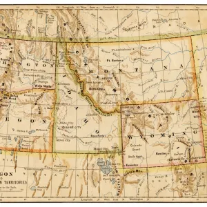
Premium Framed Print : Map of the Louisiana Purchase, 1926 (engraving)
")

")


![]()
Framed Photos From Fine Art Finder
Map of the Louisiana Purchase, 1926 (engraving)
2622463 Map of the Louisiana Purchase, 1926 (engraving) by American School, (20th century); Private Collection; (add.info.: Vintage map of the Louisiana Purchase from France in 1803; engraving, 1926. The territory was sold by Napoleon to Thomas Jefferson for million.); Photo eGraphicaArtis; American, out of copyright
Media ID 22760818
© GraphicaArtis / Bridgeman Images
Expansion Louisiana Purchase Midwest Territory Thomas Jefferson
14"x16" Premium Frame
Contemporary style Premium Wooden Frame with 8"x10" Print. Complete with 2" White Mat and 1.25" thick MDF frame. Printed on 260 gsm premium paper. Glazed with shatter proof UV coated acrylic glass. Backing is paper covered backing with rubber bumpers. Supplied ready to hang with a pre-installed sawtooth/wire hanger. Care Instructions: Spot clean with a damp cloth. Securely packaged in a clear plastic bag and envelope in a reinforced cardboard shipper
FSC Real Wood Frame and Double Mounted with White Conservation Mountboard - Professionally Made and Ready to Hang
Estimated Image Size (if not cropped) is 25.4cm x 20.3cm (10" x 8")
Estimated Product Size is 40.6cm x 35.6cm (16" x 14")
These are individually made so all sizes are approximate
Artwork printed orientated as per the preview above, with landscape (horizontal) orientation to match the source image.
FEATURES IN THESE COLLECTIONS
> Fine Art Finder
> Artists
> American School
> Fine Art Finder
> Temp Classification
> Arts
> Artists
> J
> Thomas Jefferson
> Maps and Charts
> Related Images
EDITORS COMMENTS
This vintage engraving, titled "Map of the Louisiana Purchase, 1926" takes us back to a significant moment in American history. The map showcases the vast territory acquired by the United States from France in 1803, known as the Louisiana Purchase. The intricate details and precise craftsmanship of this engraving allow us to explore the expansion of America's midwest region during that era. Spanning over 800,000 square miles, this acquisition doubled the size of the young nation at that time. As we study this historical artifact, it is fascinating to imagine Thomas Jefferson's visionary decision to negotiate with Napoleon Bonaparte for this valuable landmass. This transaction took place for an astonishing sum of $15 million dollars – a true bargain when considering its immense potential. Through this beautifully preserved illustration, we gain insight into how these newly acquired territories shaped American history and influenced westward expansion. It serves as a testament to our nation's ambition and determination. Whether you are an enthusiast of cartography or simply intrigued by American history, this print offers a glimpse into one of our country's most pivotal moments. Displayed proudly in any collection or educational setting, it sparks curiosity and invites exploration into our rich past.
MADE IN THE USA
Safe Shipping with 30 Day Money Back Guarantee
FREE PERSONALISATION*
We are proud to offer a range of customisation features including Personalised Captions, Color Filters and Picture Zoom Tools
SECURE PAYMENTS
We happily accept a wide range of payment options so you can pay for the things you need in the way that is most convenient for you
* Options may vary by product and licensing agreement. Zoomed Pictures can be adjusted in the Basket.