Premium Framed Print > Europe > France > Maps
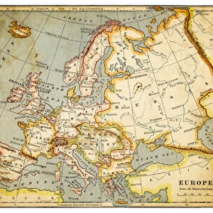
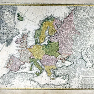
Premium Framed Print : Map of Europe (etching, 1730)
")
")


![]()
Framed Photos From Fine Art Finder
Map of Europe (etching, 1730)
LRI4706338 Map of Europe (etching, 1730) by Delisle, Guillaume (1675-1726); Private Collection; (add.info.: Map of Europe - Strong water extracted from the New Atlas containing all parts of the world" 1730 by Guillaume de L Isle (1675-1726)); Luisa Ricciarini; French, out of copyright
Media ID 23327010
© Luisa Ricciarini / Bridgeman Images
14"x16" Premium Frame
Contemporary style Premium Wooden Frame with 8"x10" Print. Complete with 2" White Mat and 1.25" thick MDF frame. Printed on 260 gsm premium paper. Glazed with shatter proof UV coated acrylic glass. Backing is paper covered backing with rubber bumpers. Supplied ready to hang with a pre-installed sawtooth/wire hanger. Care Instructions: Spot clean with a damp cloth. Securely packaged in a clear plastic bag and envelope in a reinforced cardboard shipper
FSC Real Wood Frame and Double Mounted with White Conservation Mountboard - Professionally Made and Ready to Hang
Estimated Image Size (if not cropped) is 25.4cm x 20.3cm (10" x 8")
Estimated Product Size is 40.6cm x 35.6cm (16" x 14")
These are individually made so all sizes are approximate
Artwork printed orientated as per the preview above, with landscape (horizontal) orientation to match the source image.
FEATURES IN THESE COLLECTIONS
> Fine Art Finder
> Artists
> Achille Beltrame
> Fine Art Finder
> Artists
> Guillaume Delisle
> Maps and Charts
> Related Images
> Maps and Charts
> World
EDITORS COMMENTS
This print showcases a remarkable piece of history - an etching of the "Map of Europe" from 1730. Created by the talented cartographer Guillaume de L'Isle, this intricate map offers a glimpse into the geographical landscape of Europe during the 18th century. The fine details and delicate lines etched onto this map are truly awe-inspiring. Every country, river, and mountain range is meticulously depicted, allowing viewers to immerse themselves in the rich tapestry of European geography. It serves as a testament to de L'Isle's expertise and dedication to his craft. As we gaze upon this masterpiece, we can't help but appreciate its significance in understanding how our world has evolved over time. This map was extracted from the renowned New Atlas containing all parts of the world, making it an invaluable resource for scholars and explorers alike. Preserved within a private collection, this particular print captures every nuance with precision and clarity. Thanks to Luisa Ricciarini's skillful photography, we are able to admire this historical gem without leaving our homes. Let us take a moment to marvel at this extraordinary work that not only represents Europe's past but also reminds us of our shared human journey through time.
MADE IN THE USA
Safe Shipping with 30 Day Money Back Guarantee
FREE PERSONALISATION*
We are proud to offer a range of customisation features including Personalised Captions, Color Filters and Picture Zoom Tools
SECURE PAYMENTS
We happily accept a wide range of payment options so you can pay for the things you need in the way that is most convenient for you
* Options may vary by product and licensing agreement. Zoomed Pictures can be adjusted in the Basket.