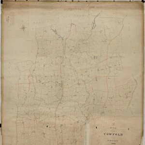
Poster Print > Europe > United Kingdom > England > Sussex > Coombes
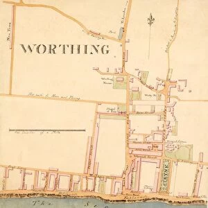
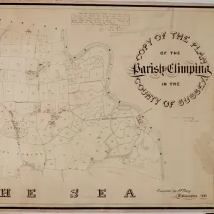
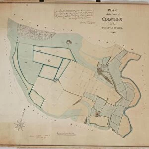
Poster Print : Coombes Tithe Map, 1840


![]()
Poster Prints from West Sussex County Council
Coombes Tithe Map, 1840
Surveyor unknown. 16 in. to 1m. Original map size 32in. × 37in.
Tithe Award Map Collection
West Sussex Record Office Ref No: TD/W38
West Sussex County Council Record Office contains a fascinating history of the county of West Sussex, England
Media ID 7915680
© West Sussex County Council - All Rights Reserved
18x24 inch Poster Print
"Step back in time with our exclusive Coombes Tithe Map, 1840 print from the Media Storehouse collection. This historic map, originally from the West Sussex Record Office, provides a fascinating glimpse into the past of Coombes, West Sussex. Dating back to 1840, this surveyor-unknown map offers intricate details of the land ownership and parcel sizes during that era. Add this beautifully detailed poster print to your home or office to add a touch of history and character to your space."
Poster prints are budget friendly enlarged prints in standard poster paper sizes. Printed on 150 gsm Matte Paper for a natural feel and supplied rolled in a tube. Great for framing and should last many years. To clean wipe with a microfiber, non-abrasive cloth or napkin. Our Archival Quality Photo Prints and Fine Art Paper Prints are printed on higher quality paper and the choice of which largely depends on your budget.
Poster prints are budget friendly enlarged prints in standard poster paper sizes (A0, A1, A2, A3 etc). Whilst poster paper is sometimes thinner and less durable than our other paper types, they are still ok for framing and should last many years. Our Archival Quality Photo Prints and Fine Art Paper Prints are printed on higher quality paper and the choice of which largely depends on your budget.
Estimated Product Size is 61.6cm x 46.3cm (24.3" x 18.2")
These are individually made so all sizes are approximate
Artwork printed orientated as per the preview above, with landscape (horizontal) orientation to match the source image.
FEATURES IN THESE COLLECTIONS
> Europe
> United Kingdom
> England
> Sussex
> Coombes
> Europe
> United Kingdom
> England
> Sussex
> Related Images
> Europe
> United Kingdom
> England
> West Sussex
> Related Images
> Maps and Charts
> Early Maps
> Maps and Charts
> Related Images
> West Sussex County Council
> West Sussex Record Office
> Tithe Award Maps, 1808-1859
EDITORS COMMENTS
This print showcases the Coombes Tithe Map from 1840, a remarkable piece of historical mapping. Although the surveyor remains unknown, their meticulous work is evident in this detailed representation. The map scale of 16 inches to 1 meter allows for a comprehensive view of the area, while its original size measuring an impressive 32 inches by 37 inches demonstrates the magnitude and importance of this document. Part of the esteemed Tithe Award Map Collection at West Sussex Record Office, this particular map holds immense value for researchers and history enthusiasts alike. Its reference number TD/W38 ensures easy access to those seeking to delve into the rich past of West Sussex County Council. Transporting us back to the early 19th century, this snapshot offers a glimpse into rural life during that era. It unveils not only geographical features but also provides insights into land ownership patterns and agricultural practices prevalent at that time. It's important to note that this photograph focuses solely on preserving history and does not imply any commercial use or affiliation with any company bearing a similar name. By showcasing these historical maps, we honor our heritage and encourage further exploration into our collective pasts.
MADE IN THE USA
Safe Shipping with 30 Day Money Back Guarantee
FREE PERSONALISATION*
We are proud to offer a range of customisation features including Personalised Captions, Color Filters and Picture Zoom Tools
SECURE PAYMENTS
We happily accept a wide range of payment options so you can pay for the things you need in the way that is most convenient for you
* Options may vary by product and licensing agreement. Zoomed Pictures can be adjusted in the Cart.