Poster Print > Universal Images Group (UIG) > Universal Images Group > Satellite and Aerial > Planet Observer 6
Poster Print : Bosnia and Herzegovina, Relief Map


![]()
Poster Prints from Universal Images Group (UIG)
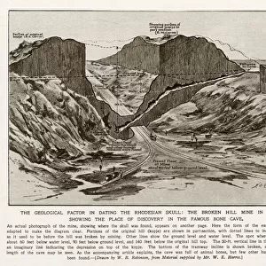
Bosnia and Herzegovina, Relief Map
Relief map of Bosnia and Herzegovina. This map was processed from elevation data
Universal Images Group (UIG) manages distribution for many leading specialist agencies worldwide
Media ID 9608767
© Planet Observer
Alsace Bas Rhin Geographical Border Relief Map Satellite View
18x24 inch Poster Print
Discover the intricacies of Bosnia and Herzegovina's topography with our stunning Relief Map Print from Media Storehouse and Universal Images Group (UIG). This captivating poster, featuring elevation data, offers an enlightening perspective on the geography of this beautiful region. Bring the depth and complexity of Bosnia and Herzegovina into your home or office space with this visually engaging and educational poster print.
Poster prints are budget friendly enlarged prints in standard poster paper sizes. Printed on 150 gsm Matte Paper for a natural feel and supplied rolled in a tube. Great for framing and should last many years. To clean wipe with a microfiber, non-abrasive cloth or napkin. Our Archival Quality Photo Prints and Fine Art Paper Prints are printed on higher quality paper and the choice of which largely depends on your budget.
Poster prints are budget friendly enlarged prints in standard poster paper sizes (A0, A1, A2, A3 etc). Whilst poster paper is sometimes thinner and less durable than our other paper types, they are still ok for framing and should last many years. Our Archival Quality Photo Prints and Fine Art Paper Prints are printed on higher quality paper and the choice of which largely depends on your budget.
Estimated Product Size is 61.6cm x 46.3cm (24.3" x 18.2")
These are individually made so all sizes are approximate
Artwork printed orientated as per the preview above, with landscape (horizontal) orientation to match the source image.
EDITORS COMMENTS
This stunning print showcases the intricate relief map of Bosnia and Herzegovina, offering a captivating glimpse into the country's diverse topography. Processed from elevation data, this meticulously crafted map presents an accurate representation of the land's physical geography. The vibrant colors and precise cartography make it a visually striking piece that effortlessly captures the essence of this European nation. The photograph, taken from a vertical perspective, allows us to appreciate every contour and detail of Bosnia and Herzegovina's terrain. With no people in sight, the focus remains solely on nature's masterpiece. From towering mountains to sprawling valleys, each element is beautifully highlighted through satellite imagery. As we explore this relief map, our eyes are drawn to its geographical border which separates Bosnia and Herzegovina from neighboring regions. This serves as a reminder of how borders shape our world while also emphasizing the uniqueness of this particular area. Displayed outdoors against a backdrop reminiscent of Bas Rhin in Alsace, France, this image transports us across continents while celebrating both artistry and science. Whether you're an avid traveler or simply fascinated by maps and landscapes, this print offers an intriguing window into one corner of Europe that is sure to captivate all who lay their eyes upon it
MADE IN THE USA
Safe Shipping with 30 Day Money Back Guarantee
FREE PERSONALISATION*
We are proud to offer a range of customisation features including Personalised Captions, Color Filters and Picture Zoom Tools
SECURE PAYMENTS
We happily accept a wide range of payment options so you can pay for the things you need in the way that is most convenient for you
* Options may vary by product and licensing agreement. Zoomed Pictures can be adjusted in the Cart.