Poster Print > Maps and Charts > Early Maps
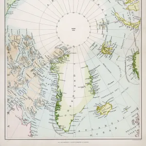
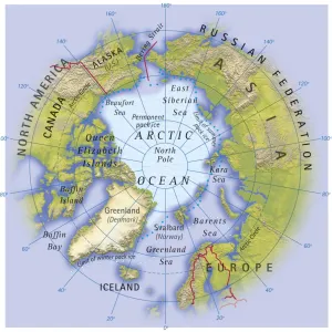
Poster Print : Map / Arctic Circle 1895


Poster Prints from Mary Evans Picture Library
Map / Arctic Circle 1895
Map of the Arctic Circle and surrounding areas
Mary Evans Picture Library makes available wonderful images created for people to enjoy over the centuries
Media ID 608851
© Mary Evans Picture Library 2015 - https://copyrighthub.org/s0/hub1/creation/maryevans/MaryEvansPictureID/10114181
Arctic Circle Maps Surrounding 1895
18x24 inch Poster Print
Discover the enchanting beauty of the Arctic Circle with our latest addition to the Media Storehouse range of poster prints. This captivating map, titled "Map / Arctic Circle 1895," hails from the esteemed Mary Evans Picture Library and is now available for purchase through Mary Evans Prints Online. Transport yourself back in time to 1895 as you explore the intricate details of this antique map, which depicts the Arctic Circle and its surrounding areas with remarkable precision. With a focus on historical accuracy, this poster print is perfect for history enthusiasts, cartography aficionados, or anyone seeking to add a touch of nostalgia to their decor. Printed on high-quality, heavyweight paper, this poster is designed to last, ensuring that the intricate details of the map are preserved for years to come. The vibrant colors and crisp lines bring the Arctic Circle to life, making it a standout addition to any home, office, or educational setting. Order your "Map / Arctic Circle 1895" poster print today and embark on an adventure through the annals of history. Transport yourself to a time when exploration was a grand and daring endeavor, and relish in the stunning detail and historical significance of this remarkable piece.
Poster prints are budget friendly enlarged prints in standard poster paper sizes. Printed on 150 gsm Matte Paper for a natural feel and supplied rolled in a tube. Great for framing and should last many years. To clean wipe with a microfiber, non-abrasive cloth or napkin. Our Archival Quality Photo Prints and Fine Art Paper Prints are printed on higher quality paper and the choice of which largely depends on your budget.
Poster prints are budget friendly enlarged prints in standard poster paper sizes (A0, A1, A2, A3 etc). Whilst poster paper is sometimes thinner and less durable than our other paper types, they are still ok for framing and should last many years. Our Archival Quality Photo Prints and Fine Art Paper Prints are printed on higher quality paper and the choice of which largely depends on your budget.
Estimated Product Size is 61.6cm x 46.3cm (24.3" x 18.2")
These are individually made so all sizes are approximate
Artwork printed orientated as per the preview above, with landscape (horizontal) orientation to match the source image.
FEATURES IN THESE COLLECTIONS
> Maps and Charts
> Early Maps
> Maps and Charts
> Related Images
> Popular Themes
> Maps and Charts
EDITORS COMMENTS
This stunning print captures a piece of history with the Map of the Arctic Circle from 1895. The intricate details and design of this map provide a fascinating glimpse into the past, showcasing the geographical layout of the Arctic Circle and its surrounding areas during that time period.
The historical significance of this map is undeniable, as it offers valuable insights into how explorers navigated through these icy waters over a century ago. From the rugged terrain to the icy waters, every element on this map tells a story of adventure and discovery in one of Earth's most remote regions.
As we study this map closely, we can't help but marvel at the dedication and bravery of those who ventured into these uncharted territories in search of new lands and resources. The precision and accuracy with which this map was created are truly remarkable, highlighting both scientific knowledge and artistic skill.
Whether you're a history buff or simply appreciate beautiful cartography, this Map of the Arctic Circle from 1895 is sure to captivate your imagination. It serves as a reminder of our planet's vastness and diversity, urging us to explore beyond our comfort zones and embrace new horizons just waiting to be discovered.
MADE IN THE USA
Safe Shipping with 30 Day Money Back Guarantee
FREE PERSONALISATION*
We are proud to offer a range of customisation features including Personalised Captions, Color Filters and Picture Zoom Tools
SECURE PAYMENTS
We happily accept a wide range of payment options so you can pay for the things you need in the way that is most convenient for you
* Options may vary by product and licensing agreement. Zoomed Pictures can be adjusted in the Cart.