Poster Print > Europe > United Kingdom > England > London > Fire Brigade
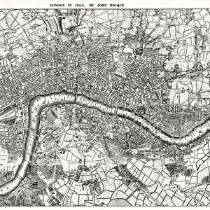
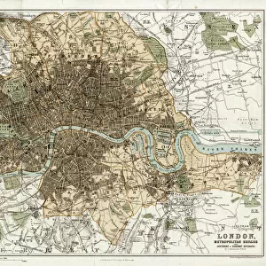
Poster Print : Map of the Greater London area


![]()
Poster Prints from Mary Evans Picture Library
Map of the Greater London area
Map of the Greater London area with council areas marked. Date: mid-20th century
Mary Evans Picture Library makes available wonderful images created for people to enjoy over the centuries
Media ID 23043928
© London Fire Brigade / Mary Evans Picture Library
Annotated Annotation Area Areas Authorities Authority Berks Buckinghamshire Bucks Council Councils Districts Essex Greater Hertfordshire Herts Maps Marked Postal Surrey
18x24 inch Poster Print
Discover the rich history of Greater London with our stunning Map of the Greater London area poster print. This beautifully detailed, mid-20th century map, sourced from Mary Evans Prints Online, showcases the council areas that once defined the boundaries of this iconic metropolis. Bring a piece of London's past into your home or office with this captivating and informative poster print from Media Storehouse. Perfect for history enthusiasts, urban planners, or anyone with an appreciation for the evolution of our vibrant city.
Poster prints are budget friendly enlarged prints in standard poster paper sizes. Printed on 150 gsm Matte Paper for a natural feel and supplied rolled in a tube. Great for framing and should last many years. To clean wipe with a microfiber, non-abrasive cloth or napkin. Our Archival Quality Photo Prints and Fine Art Paper Prints are printed on higher quality paper and the choice of which largely depends on your budget.
Poster prints are budget friendly enlarged prints in standard poster paper sizes (A0, A1, A2, A3 etc). Whilst poster paper is sometimes thinner and less durable than our other paper types, they are still ok for framing and should last many years. Our Archival Quality Photo Prints and Fine Art Paper Prints are printed on higher quality paper and the choice of which largely depends on your budget.
Estimated Product Size is 61.6cm x 46.3cm (24.3" x 18.2")
These are individually made so all sizes are approximate
Artwork printed orientated as per the preview above, with landscape (horizontal) orientation to match the source image.
FEATURES IN THESE COLLECTIONS
> Mary Evans Prints Online
> New Images August 2021
> Europe
> United Kingdom
> England
> Buckinghamshire
> Related Images
> Europe
> United Kingdom
> England
> Essex
> Related Images
> Europe
> United Kingdom
> England
> Greater London
> Related Images
> Europe
> United Kingdom
> England
> Hertfordshire
> Related Images
> Europe
> United Kingdom
> England
> London
> Fire Brigade
> Europe
> United Kingdom
> England
> Surrey
> Related Images
> Maps and Charts
> Related Images
EDITORS COMMENTS
This mid-20th century map print of Greater London showcases the administrative divisions of the area, with the London Fire Brigade (LFB) service districts and the boundaries of the various local authorities and councils meticulously marked. The map provides a fascinating glimpse into the historical organization of London's administrative structure during this time. The London Fire Brigade, established in 1865, is responsible for firefighting and emergency medical services in Greater London. The map illustrates the LFB's jurisdiction, which covers the entirety of Greater London, including the City of London and the surrounding boroughs. The map also highlights the various local authorities and councils that governed different areas of Greater London during the mid-20th century. These include the County Boroughs of Bexley, Bromley, Croydon, Dagenham, Dartford, Ealing, Greenwich, Hackney, Haringey, Islington, Lewisham, Merton, Newham, Redbridge, Southwark, Sutton, Tower Hamlets, Wandsworth, and Walthamstow. Additionally, the map shows the County Councils of Surrey, Kent, Essex, Hertfordshire, Buckinghamshire, and Berkshire, which had some responsibilities in the outskirts of Greater London. This annotated map is an essential resource for researchers, historians, and anyone interested in understanding the administrative structure of London during the mid-20th century. It offers valuable insights into the complex web of local government entities that governed the Greater London area and the role of the London Fire Brigade in providing essential services to the community.
MADE IN THE USA
Safe Shipping with 30 Day Money Back Guarantee
FREE PERSONALISATION*
We are proud to offer a range of customisation features including Personalised Captions, Color Filters and Picture Zoom Tools
SECURE PAYMENTS
We happily accept a wide range of payment options so you can pay for the things you need in the way that is most convenient for you
* Options may vary by product and licensing agreement. Zoomed Pictures can be adjusted in the Cart.