Poster Print > Maps and Charts > Americas
Poster Print : Map / North America 1702


![]()
Poster Prints from Mary Evans Picture Library
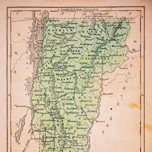
Map / North America 1702
Map of North America
Mary Evans Picture Library makes available wonderful images created for people to enjoy over the centuries
Media ID 608901
© Mary Evans Picture Library 2015 - https://copyrighthub.org/s0/hub1/creation/maryevans/MaryEvansPictureID/10114292
18x24 inch Poster Print
Discover the rich history of North America with our captivating Map / North America 1702 print from the Media Storehouse collection. This antique map, sourced from the esteemed Mary Evans Picture Library via Mary Evans Prints Online, offers a fascinating glimpse into the cartographic knowledge of the early 18th century. With intricate detail and vibrant colors, this vintage map print makes for an excellent addition to any home or office wall. Transport yourself back in time and embellish your space with this beautiful piece of historical cartography.
Poster prints are budget friendly enlarged prints in standard poster paper sizes. Printed on 150 gsm Matte Paper for a natural feel and supplied rolled in a tube. Great for framing and should last many years. To clean wipe with a microfiber, non-abrasive cloth or napkin. Our Archival Quality Photo Prints and Fine Art Paper Prints are printed on higher quality paper and the choice of which largely depends on your budget.
Poster prints are budget friendly enlarged prints in standard poster paper sizes (A0, A1, A2, A3 etc). Whilst poster paper is sometimes thinner and less durable than our other paper types, they are still ok for framing and should last many years. Our Archival Quality Photo Prints and Fine Art Paper Prints are printed on higher quality paper and the choice of which largely depends on your budget.
Estimated Product Size is 61.6cm x 46.3cm (24.3" x 18.2")
These are individually made so all sizes are approximate
Artwork printed orientated as per the preview above, with landscape (horizontal) orientation to match the source image.
FEATURES IN THESE COLLECTIONS
> Maps and Charts
> Early Maps
> Maps and Charts
> Related Images
> North America
> Related Images
EDITORS COMMENTS
This stunning print of a historical map of North America from 1702 takes us back in time to the early days of exploration and colonization. The intricate details and vibrant colors bring this piece of history to life, showcasing the vastness and diversity of the continent as it was known over three centuries ago.
As we study this map, we can see how different regions were labeled and divided by European powers, with names that may be unfamiliar or have changed over time. From New France to Spanish Florida, each area tells a story of conquest, trade, and cultural exchange that shaped the development of North America.
The borders are not as clearly defined as they are today, reflecting a time when boundaries were constantly shifting due to wars, treaties, and negotiations between colonial powers. Rivers flow freely across the landmasses while mountain ranges rise majestically in the background, reminding us of the natural beauty that has always been a part of this continent.
Whether you are a history buff or simply appreciate beautiful artwork, this map is sure to captivate your imagination and spark curiosity about the past. It serves as a reminder of how far we have come since 1702 and how much more there is still left to discover about North America's rich heritage.
MADE IN THE USA
Safe Shipping with 30 Day Money Back Guarantee
FREE PERSONALISATION*
We are proud to offer a range of customisation features including Personalised Captions, Color Filters and Picture Zoom Tools
SECURE PAYMENTS
We happily accept a wide range of payment options so you can pay for the things you need in the way that is most convenient for you
* Options may vary by product and licensing agreement. Zoomed Pictures can be adjusted in the Cart.