Poster Print > Europe > Malta > Maps
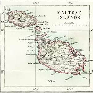
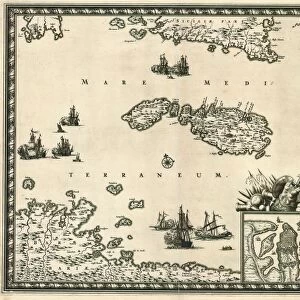
Poster Print : Map of Malta. Island. Mediterranean Sea. Italian engraving


![]()
Poster Prints From Mary Evans Picture Library
Map of Malta. Island. Mediterranean Sea. Italian engraving
Map of Malta. Island. Mediterranean Sea. Italian engraving. 16th century
Mary Evans Picture Library makes available wonderful images created for people to enjoy over the centuries
Media ID 14337070
© Thaliastock / Mary Evans
1558 Cartography Malta Mapping Mediterranean
18x24 inch Poster Print
Bring the rich history of Malta into your home or office with our stunning poster prints from the Media Storehouse collection. Featuring an exquisite 16th century Italian engraving of a map of Malta and the Mediterranean Sea, sourced from the esteemed Mary Evans Prints Online, these poster prints transport you back in time. Perfect for history enthusiasts, travelers, or anyone with a love for the Mediterranean, these high-quality prints are a must-have addition to your decor. Add a touch of history and culture to your space with our Map of Malta poster print.
Poster prints are budget friendly enlarged prints in standard poster paper sizes. Printed on 150 gsm Matte Paper for a natural feel and supplied rolled in a tube. Great for framing and should last many years. To clean wipe with a microfiber, non-abrasive cloth or napkin. Our Archival Quality Photo Prints and Fine Art Paper Prints are printed on higher quality paper and the choice of which largely depends on your budget.
Poster prints are budget friendly enlarged prints in standard poster paper sizes (A0, A1, A2, A3 etc). Whilst poster paper is sometimes thinner and less durable than our other paper types, they are still ok for framing and should last many years. Our Archival Quality Photo Prints and Fine Art Paper Prints are printed on higher quality paper and the choice of which largely depends on your budget.
Estimated Product Size is 61.6cm x 46.3cm (24.3" x 18.2")
These are individually made so all sizes are approximate
Artwork printed orientated as per the preview above, with landscape (horizontal) orientation to match the source image.
FEATURES IN THESE COLLECTIONS
> Europe
> Malta
> Related Images
> Maps and Charts
> Early Maps
> Maps and Charts
> Italy
MADE IN THE USA
Safe Shipping with 30 Day Money Back Guarantee
FREE PERSONALISATION*
We are proud to offer a range of customisation features including Personalised Captions, Color Filters and Picture Zoom Tools
SECURE PAYMENTS
We happily accept a wide range of payment options so you can pay for the things you need in the way that is most convenient for you
* Options may vary by product and licensing agreement. Zoomed Pictures can be adjusted in the Basket.