Poster Print > Europe > Austria > Maps
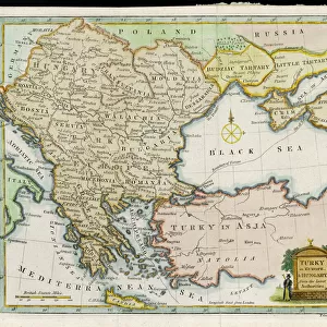
Poster Print : Map / Europe / Austria 1857


![]()
Poster Prints from Mary Evans Picture Library
Map / Europe / Austria 1857
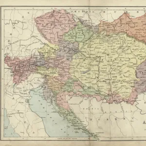
Map of the Austrian Empire
Mary Evans Picture Library makes available wonderful images created for people to enjoy over the centuries
Media ID 581421
© Mary Evans Picture Library 2015 - https://copyrighthub.org/s0/hub1/creation/maryevans/MaryEvansPictureID/10027192
18x24 inch Poster Print
Introducing the captivating "Map / Europe / Austria 1857" print from our Media Storehouse collection, brought to you by Mary Evans Picture Library via Mary Evans Prints Online. This exquisite piece of historical cartography depicts the Austrian Empire in Europe during the year 1857. Delve into the intricacies of the Austrian territories and neighboring countries with this detailed and beautifully preserved map. Add a touch of history and geography to your walls with this unique and captivating print. Perfect for history enthusiasts, educators, and anyone with an appreciation for the richness of the past. Order now and bring a piece of the past into your home or office.
Poster prints are budget friendly enlarged prints in standard poster paper sizes. Printed on 150 gsm Matte Paper for a natural feel and supplied rolled in a tube. Great for framing and should last many years. To clean wipe with a microfiber, non-abrasive cloth or napkin. Our Archival Quality Photo Prints and Fine Art Paper Prints are printed on higher quality paper and the choice of which largely depends on your budget.
Poster prints are budget friendly enlarged prints in standard poster paper sizes (A0, A1, A2, A3 etc). Whilst poster paper is sometimes thinner and less durable than our other paper types, they are still ok for framing and should last many years. Our Archival Quality Photo Prints and Fine Art Paper Prints are printed on higher quality paper and the choice of which largely depends on your budget.
Estimated Product Size is 61.6cm x 46.3cm (24.3" x 18.2")
These are individually made so all sizes are approximate
Artwork printed orientated as per the preview above, with landscape (horizontal) orientation to match the source image.
FEATURES IN THESE COLLECTIONS
> Europe
> Austria
> Related Images
> Europe
> Related Images
> Maps and Charts
> Early Maps
> Maps and Charts
> Related Images
EDITORS COMMENTS
This stunning print captures a piece of history with its detailed map of the Austrian Empire from 1857. The intricate borders and boundaries of this European country are beautifully illustrated, showcasing the vast expanse of land that once made up this powerful empire.
As we gaze upon this historical map, we are transported back in time to an era where Austria held significant influence over much of Europe. The names of cities and regions long forgotten come to life on this aged parchment, reminding us of the rich cultural heritage that has shaped modern-day Austria.
The craftsmanship and attention to detail in this map are truly remarkable, highlighting the skill and precision required to create such a masterpiece in a time before modern technology. Each line and symbol tells a story of conquests, alliances, and territorial disputes that have shaped the course of European history.
Whether you have a personal connection to Austria or simply appreciate historical artifacts, this print is sure to captivate your imagination. Display it proudly in your home or office as a reminder of the enduring legacy left behind by one of Europe's most influential empires.
MADE IN THE USA
Safe Shipping with 30 Day Money Back Guarantee
FREE PERSONALISATION*
We are proud to offer a range of customisation features including Personalised Captions, Color Filters and Picture Zoom Tools
SECURE PAYMENTS
We happily accept a wide range of payment options so you can pay for the things you need in the way that is most convenient for you
* Options may vary by product and licensing agreement. Zoomed Pictures can be adjusted in the Cart.