Poster Print > Maps and Charts > Early Maps
Poster Print : MAP / EUROPE 1763


![]()
Poster Prints from Mary Evans Picture Library
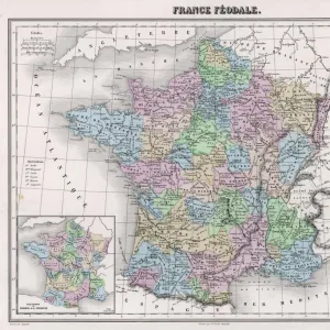
MAP / EUROPE 1763
Map of Europe
Mary Evans Picture Library makes available wonderful images created for people to enjoy over the centuries
Media ID 608778
© Mary Evans Picture Library 2015 - https://copyrighthub.org/s0/hub1/creation/maryevans/MaryEvansPictureID/10113932
18x24 inch Poster Print
Poster prints are budget friendly enlarged prints in standard poster paper sizes. Printed on 150 gsm Matte Paper for a natural feel and supplied rolled in a tube. Great for framing and should last many years. To clean wipe with a microfiber, non-abrasive cloth or napkin. Our Archival Quality Photo Prints and Fine Art Paper Prints are printed on higher quality paper and the choice of which largely depends on your budget.
Poster prints are budget friendly enlarged prints in standard poster paper sizes (A0, A1, A2, A3 etc). Whilst poster paper is sometimes thinner and less durable than our other paper types, they are still ok for framing and should last many years. Our Archival Quality Photo Prints and Fine Art Paper Prints are printed on higher quality paper and the choice of which largely depends on your budget.
Estimated Product Size is 61.6cm x 46.3cm (24.3" x 18.2")
These are individually made so all sizes are approximate
Artwork printed orientated as per the preview above, with landscape (horizontal) orientation to match the source image.
FEATURES IN THESE COLLECTIONS
> Europe
> Related Images
> Maps and Charts
> Early Maps
> Maps and Charts
> Related Images
EDITORS COMMENTS
This stunning print of a historical map of Europe from 1763 is a captivating glimpse into the past. The intricate details and vibrant colors bring to life the political landscape of Europe during this pivotal moment in history. As we study the borders, territories, and cities depicted on this map, we are transported back to a time when empires rose and fell, alliances were forged and broken, and wars reshaped the continent.
The year 1763 marked the end of the Seven Years' War and saw significant changes in European power dynamics. This map captures these shifts with precision, showcasing how nations such as France, Spain, Russia, Prussia, Austria-Hungary, and others controlled vast swaths of land across Europe.
As we admire this piece from Mary Evans Picture Library's collection, we can't help but marvel at the artistry and skill that went into creating such a detailed representation of the world as it was over two centuries ago. It serves as a reminder of how far we have come since then while also highlighting the enduring importance of understanding our shared history.
Whether you're a history buff or simply appreciate beautiful works of art, this print is sure to spark your curiosity and imagination as you explore the intricacies of Europe's past.
MADE IN THE USA
Safe Shipping with 30 Day Money Back Guarantee
FREE PERSONALISATION*
We are proud to offer a range of customisation features including Personalised Captions, Color Filters and Picture Zoom Tools
SECURE PAYMENTS
We happily accept a wide range of payment options so you can pay for the things you need in the way that is most convenient for you
* Options may vary by product and licensing agreement. Zoomed Pictures can be adjusted in the Cart.