Poster Print > Maps and Charts > Africa
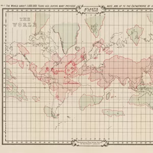
Poster Print : Map of Atlantis / Kircher


![]()
Poster Prints from Mary Evans Picture Library
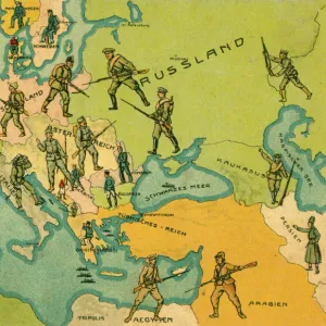
Map of Atlantis / Kircher
Map of Atlantis showing position relative to Europe, Africa and America (albeit upside down)
Mary Evans Picture Library makes available wonderful images created for people to enjoy over the centuries
Media ID 573464
© Mary Evans Picture Library 2015 - https://copyrighthub.org/s0/hub1/creation/maryevans/MaryEvansPictureID/10008341
Atlantis Folk Lore Kircher Mythical Places Position Relative Upside Albeit
18x24 inch Poster Print
Discover the captivating allure of the lost city of Atlantis with our exquisite range of poster prints from Media Storehouse, featuring the intriguing "Map of Atlantis / Kircher" by Mary Evans Picture Library. This mesmerizing map, sourced from Mary Evans Prints Online, offers a fascinating depiction of the fabled city's supposed location in relation to Europe, Africa, and America. With its intricate detail and upside-down perspective, this captivating print is a must-have for history buffs, Atlantis enthusiasts, and anyone with a curiosity for the mysteries of the past. Bring the enigma of Atlantis into your home or office and ignite endless conversations with this stunning, high-quality poster print.
Poster prints are budget friendly enlarged prints in standard poster paper sizes. Printed on 150 gsm Matte Paper for a natural feel and supplied rolled in a tube. Great for framing and should last many years. To clean wipe with a microfiber, non-abrasive cloth or napkin. Our Archival Quality Photo Prints and Fine Art Paper Prints are printed on higher quality paper and the choice of which largely depends on your budget.
Poster prints are budget friendly enlarged prints in standard poster paper sizes (A0, A1, A2, A3 etc). Whilst poster paper is sometimes thinner and less durable than our other paper types, they are still ok for framing and should last many years. Our Archival Quality Photo Prints and Fine Art Paper Prints are printed on higher quality paper and the choice of which largely depends on your budget.
Estimated Product Size is 61.6cm x 46.3cm (24.3" x 18.2")
These are individually made so all sizes are approximate
Artwork printed orientated as per the preview above, with landscape (horizontal) orientation to match the source image.
FEATURES IN THESE COLLECTIONS
> Africa
> Related Images
> Europe
> Related Images
> Maps and Charts
> Early Maps
> Maps and Charts
> Related Images
EDITORS COMMENTS
This intriguing map print, titled "Nova Terrae Australis Tabula," created by the renowned 17th-century German polymath Athanasius Kircher, presents a captivating representation of the mythical land of Atlantis. Contrary to its title suggesting a new land in the Southern Hemisphere, this map is, in fact, a depiction of the legendary sunken city. Positioned upside down relative to Europe, Africa, and America, Atlantis is shown as a vast island, located in the Atlantic Ocean, west of the Mediterranean Sea. The map's historical significance lies in its contribution to the folklore and mythology surrounding Atlantis, which has intrigued scholars and the public alike for centuries. Athanasius Kircher, a versatile intellectual, was a Jesuit priest, scholar, and professor of archaeology, Egyptology, and ethnology at the Roman College in Rome. He was a prolific writer and inventor, known for his wide-ranging knowledge and innovative ideas. The map of Atlantis is just one of his many works that showcase his curiosity and fascination with the unknown. The map's placement of Atlantis near the Americas and Africa may reflect the theories of ancient Greek philosopher Plato, who first wrote about Atlantis in his dialogues "Timaeus" and "Critias." Plato described Atlantis as a powerful and advanced civilization that existed around 9,000 years before his time, with a strong military and cultural influence on the Mediterranean world. The map's upside-down positioning could be a reflection of the mysterious and enigmatic nature of Atlantis, a place that continues to captivate the imagination and inspire countless stories and legends. This map print serves as a fascinating reminder of the enduring allure of Atlantis and the role that historical and mythical narratives play in shaping our understanding of the world and our place within it.
MADE IN THE USA
Safe Shipping with 30 Day Money Back Guarantee
FREE PERSONALISATION*
We are proud to offer a range of customisation features including Personalised Captions, Color Filters and Picture Zoom Tools
SECURE PAYMENTS
We happily accept a wide range of payment options so you can pay for the things you need in the way that is most convenient for you
* Options may vary by product and licensing agreement. Zoomed Pictures can be adjusted in the Cart.