Poster Print > Asia > Iran > Maps
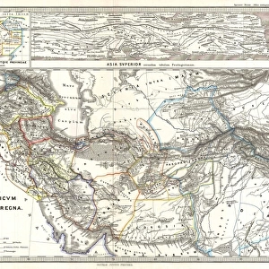
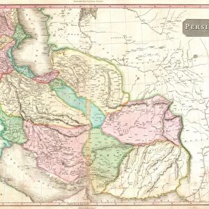
Poster Print : Map / Asia / Persia 19C


![]()
Poster Prints from Mary Evans Picture Library
Map / Asia / Persia 19C
Map of Persia (Iran)
Mary Evans Picture Library makes available wonderful images created for people to enjoy over the centuries
Media ID 608860
© Mary Evans Picture Library 2015 - https://copyrighthub.org/s0/hub1/creation/maryevans/MaryEvansPictureID/10114195
18x24 inch Poster Print
Discover the rich history and culture of Persia (Iran) with our stunning poster prints from the Media Storehouse collection, featuring the captivating map titled "Map / Asia / Persia 19C" from Mary Evans Picture Library. This exquisite map, sourced from Mary Evans Prints Online, transports you back in time to the 19th century, showcasing intricate details of Persia's geography during that era. Add this beautiful and informative piece to your home or office space to ignite curiosity and inspire learning. Order your Persia 19C Map poster print today and bring a piece of history into your world.
Poster prints are budget friendly enlarged prints in standard poster paper sizes. Printed on 150 gsm Matte Paper for a natural feel and supplied rolled in a tube. Great for framing and should last many years. To clean wipe with a microfiber, non-abrasive cloth or napkin. Our Archival Quality Photo Prints and Fine Art Paper Prints are printed on higher quality paper and the choice of which largely depends on your budget.
Poster prints are budget friendly enlarged prints in standard poster paper sizes (A0, A1, A2, A3 etc). Whilst poster paper is sometimes thinner and less durable than our other paper types, they are still ok for framing and should last many years. Our Archival Quality Photo Prints and Fine Art Paper Prints are printed on higher quality paper and the choice of which largely depends on your budget.
Estimated Product Size is 61.6cm x 46.3cm (24.3" x 18.2")
These are individually made so all sizes are approximate
Artwork printed orientated as per the preview above, with landscape (horizontal) orientation to match the source image.
FEATURES IN THESE COLLECTIONS
> Asia
> Iran
> Related Images
> Asia
> Related Images
> Maps and Charts
> Early Maps
> Maps and Charts
> Related Images
EDITORS COMMENTS
This stunning print of a 19th-century map of Persia (Iran) from the Mary Evans Picture Library is a captivating glimpse into the historical geography of Asia. The intricate details and vibrant colors bring to life the rich history and cultural significance of this region.
As we study this map, we are transported back in time to an era when cartography was both an art form and a scientific endeavor. The careful craftsmanship and attention to detail evident in every line and symbol on this map speak to the skill and dedication of the cartographer who created it.
Persia, with its ancient cities, majestic mountains, and vast deserts, is depicted with precision and beauty on this map. From Tehran to Isfahan, Shiraz to Tabriz, each place name evokes images of a bygone era filled with intrigue and adventure.
Whether you are a history buff, a geography enthusiast, or simply appreciate fine artistry, this print is sure to captivate your imagination. Display it proudly in your home or office as a conversation piece that sparks curiosity about the past.
Let this Map of Persia serve as a reminder of the enduring legacy of one of Asia's most storied civilizations.
MADE IN THE USA
Safe Shipping with 30 Day Money Back Guarantee
FREE PERSONALISATION*
We are proud to offer a range of customisation features including Personalised Captions, Color Filters and Picture Zoom Tools
SECURE PAYMENTS
We happily accept a wide range of payment options so you can pay for the things you need in the way that is most convenient for you
* Options may vary by product and licensing agreement. Zoomed Pictures can be adjusted in the Cart.