Poster Print > Africa > Egypt > Maps
Poster Print : Map of the Ancient Persian Empire


Poster Prints From Mary Evans Picture Library
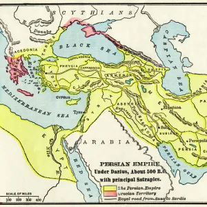
Map of the Ancient Persian Empire
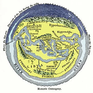
Map of the Ancient Persian Empire, encompassing Greece to the north west, Arabia to the south east, Egypt and Libya to the south west and deep in the Caucasus in the north east. Date: 1798
Mary Evans Picture Library makes available wonderful images created for people to enjoy over the centuries
Media ID 11575329
© Mary Evans / Grenville Collins Postcard Collection
1798 Arabian Caucasus Chart Gulf Maps Mediterranean Persian Persians Scythia Territories Territory
18x24 inch Poster Print
Discover the rich history of the Ancient Persian Empire with our stunning poster prints from Media Storehouse. This captivating map, dating back to 1798, beautifully illustrates the vast expanse of the Persian Empire, reaching from Greece in the northwest to Arabia in the south east, Egypt and Libya in the south west, and deep into the Caucasus in the north east. Bring the history of this ancient civilization into your home or office with our high-quality, rights managed prints from Mary Evans Prints Online. Transport yourself back in time and let this magnificent map serve as a conversation starter or a source of inspiration. Order yours today and add a touch of history to your space.
Poster prints are budget friendly enlarged prints in standard poster paper sizes. Printed on 150 gsm Matte Paper for a natural feel and supplied rolled in a tube. Great for framing and should last many years. To clean wipe with a microfiber, non-abrasive cloth or napkin. Our Archival Quality Photo Prints and Fine Art Paper Prints are printed on higher quality paper and the choice of which largely depends on your budget.
Poster prints are budget friendly enlarged prints in standard poster paper sizes (A0, A1, A2, A3 etc). Whilst poster paper is sometimes thinner and less durable than our other paper types, they are still ok for framing and should last many years. Our Archival Quality Photo Prints and Fine Art Paper Prints are printed on higher quality paper and the choice of which largely depends on your budget.
Estimated Product Size is 61.6cm x 46.3cm (24.3" x 18.2")
These are individually made so all sizes are approximate
Artwork printed orientated as per the preview above, with landscape (horizontal) orientation to match the source image.
FEATURES IN THESE COLLECTIONS
> Africa
> Egypt
> Related Images
> Africa
> Libya
> Related Images
> Asia
> India
> Related Images
> Asia
> Turkey
> Related Images
> Europe
> Greece
> Related Images
> Maps and Charts
> Early Maps
> Popular Themes
> Maps and Charts
EDITORS COMMENTS
This stunning map print, created in the late 18th century, offers a captivating glimpse into the vast territories of the Ancient Persian Empire as it existed in 1798. The Persian Empire, ruled by the Persian monarchs, reached its zenith during this period, extending from Greece in the northwest, through modern-day Turkey and the Middle East, to Egypt and Libya in the southwest, deep into the Caucasus in the northeast, and even touching the Indian subcontinent. The map meticulously illustrates the empire's diverse geographical features, including the fertile plains of Mesopotamia, the rugged mountains of the Caucasus, the vast deserts of Arabia, and the shimmering waters of the Gulf Sea. The territories under Persian rule are depicted in rich detail, with cities, rivers, and mountains all clearly marked. The map also highlights the empire's strategic locations, such as the crucial trade routes that connected the Mediterranean world to the Indian subcontinent. The Persian Empire's influence extended far beyond its borders, with the Scythians to the north and India to the east also depicted on the map. This historical map is an invaluable resource for scholars, educators, and anyone interested in the ancient world. It offers a unique perspective on the size and scope of one of history's most powerful empires, and serves as a reminder of the rich cultural heritage that continues to shape our world today.
MADE IN THE USA
Safe Shipping with 30 Day Money Back Guarantee
FREE PERSONALISATION*
We are proud to offer a range of customisation features including Personalised Captions, Color Filters and Picture Zoom Tools
SECURE PAYMENTS
We happily accept a wide range of payment options so you can pay for the things you need in the way that is most convenient for you
* Options may vary by product and licensing agreement. Zoomed Pictures can be adjusted in the Basket.